Difference between revisions of "Darjeeling"
(→External Links) |
Symorsebrown (talk | contribs) (Amend image) |
||
| Line 1: | Line 1: | ||
{{Locations_Infobox | {{Locations_Infobox | ||
|presidency= [[Bengal (Presidency)|Bengal]] | |presidency= [[Bengal (Presidency)|Bengal]] | ||
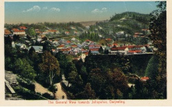
| − | |image=Darjeeling.jpg | + | |image=View towards Jallapahar, Darjeeling.jpg |
|coordinates= [http://maps.google.com/maps?ll=27.037559,88.263044&spn=0.1,0.1&t=m&q=27.037559,88.263044 27.037559, 88.263044] | |coordinates= [http://maps.google.com/maps?ll=27.037559,88.263044&spn=0.1,0.1&t=m&q=27.037559,88.263044 27.037559, 88.263044] | ||
|altitude= 2,134 m (7,001 ft) | |altitude= 2,134 m (7,001 ft) | ||
Revision as of 14:48, 9 April 2012
| Darjeeling | |
|---|---|

| |
| Presidency: Bengal | |
| Coordinates: | 27.037559, 88.263044 |
| Altitude: | 2,134 m (7,001 ft) |
| Present Day Details | |
| Place Name: | Darjeeling |
| State/Province: | West Bengal |
| Country: | India |
| Transport links | |
| Darjeeling-Himalayan Railway | |
Darjeeling was a hill station in Bengal.
There were military cantonments at Jalapahar (established 1848), Darjeeling and at Lebong, situated below Darjeeling about eight miles away. Lebong cantonment was established in 1882 as part of the Jalapahar cantonment, and became a separate cantonment in 1895.[1]
Records
- The British Library has the following book in its catalogue:
Taylor’s Maps of the following Tea Districts, Darjeeling, Terai, Jalpaiguri and Dooars, Darrang, Golaghat, Jorhat Nowgong, Sibsagar, Lakhimpur, Dibrugarh, Cachar, Sylhet, with complete Index to all Tea Gardens, published 1910
- The Australian newspaper dated 1 August 2009 has an article about a hotel in Darjeeling “where the clock stopped ticking circa 1930”, and where the library has a substantial collection relating to India's railways.
Cemeteries
A BACSA (British Association for Cemeteries in South Asia) cemetery publication is
- Darjeeling and the Dooars: Christian Cemeteries and Memorials 1842–1995 by Eileen Hewson, 2006. A record of the cemeteries and isolated graves from this corner of India with MIs and biographical notes on the planters and other notable tombs. 93pp, 23 illustrations, and map
BACSA are in the process of putting the indexes to its cemetery books online and these indexes are free to browse. If an indexed name is of interest then application can be made to BACSA for details of the relevant burial inscription - charges apply for this service.
Darjeeling’s English Cemetery by Rebecca Bragg 6 November 2009 darjeelingtimes.com. It was also known as the Hooker Road Cemetery or Hill Cart Road Cemetery according to the comments of Peter J. Karthak, 8 November 2009. He also mentions other cemeteries, including the Jewish Cemetery.
Related Articles
- Tea Plantation
- Darjeeling-Himalayan Railway
- Darjeeling Images Fibiwiki page containing various images of Darjeeling - click on thumbnails to expand.
External Links
- Wikipedia
- Darjeeling from the website Koi-Hai
- Darjeeling Tea History
- Photograph of a tea plantation, Darjeeling.
- Photos of Darjeeling from Old Indian Photos
- Old photographs of Darjeeling from the Das Studio Photo Archives from Ratna D Pradhan’s Himalayan Light: Images of the Himalayas
- Old Mount Hermon Students' Association (UK)
- History of Darjeeling from Windamerehotel.com
- The cantonment at Lebong 1910 Postcard from Images of Asia
Online books
- Newman's Guide to Darjeeling and Its Surroundings, Historical & Descriptive 1900 Archive.org
- History Of The Darjeeling District by E C Dozey 1917 is available to read online on the Digital Library of India website. Refer Online books-Digital Library of India for more details about this site. A chapter on schools commences computer page 99, and a chapter on cemeteries, with details of some burials, commences computer page 140. Note some pages appear to be missing. A revised 2nd edition, published c 1922 and titled A Concise History of the Darjeeling District by E C Dozey is also available to read online on the Digital Library of India website. The chapter on cemeteries commences actual page 146, computer page 189.
- The Magic Mountains: Hill Stations and the British Raj by Dane Kennedy, 1996 University of California Press
- “Darjeeling” from Bengal and Assam, Behar and Orissa : their history, people, commerce and industrial resources by Somerset Playne 1917 Archive.org
- Bengal District Gazetteers: Darjeeling by L.S.S.O’Malley (reprint 1985/1999, original 1907) is available to download as a searchable pdf file at DSpace at West Bengal State Central Library. Also available as Google Books Preview
References
- ↑ Dr. Wangyal's Column : Discursive Hills 1 November 2008 Darjeelingtimes.com