Difference between revisions of "Gwalior"
Jump to navigation
Jump to search
(→Historical books online) |
|||
| Line 21: | Line 21: | ||
===Historical books online=== | ===Historical books online=== | ||
*[http://books.google.com.au/books?id=U6_bUukB-nIC&pg=PA371 "Sindhia’s or Gwalior Territories"] page 371 ''The Bengal and Agra Annual Guide and Gazetteer for 1842 Volume II'' Google Books | *[http://books.google.com.au/books?id=U6_bUukB-nIC&pg=PA371 "Sindhia’s or Gwalior Territories"] page 371 ''The Bengal and Agra Annual Guide and Gazetteer for 1842 Volume II'' Google Books | ||
| + | *[https://archive.org/stream/b21452404#page/370/mode/2up Morar, Gwalior] page 370 ''Report of the Commissioners Appointed to Inquire into the Sanitary State of the Army in India : with Abstract of Evidence, and of Reports Received from Indian Military Stations'' 1864 Archive.org | ||
{{#widget:Google PlusOne | {{#widget:Google PlusOne | ||
Revision as of 02:44, 5 April 2015
| Gwalior | |
|---|---|

| |
| Presidency: Bengal | |
| Coordinates: | 26.229876°N 78.16924°E |
| Altitude: | 196 m (643 ft) |
| Present Day Details | |
| Place Name: | Gwalior |
| State/Province: | Madhya Pradesh |
| Country: | India |
| Transport links | |
| North Central Railway Gwalior Light Railway | |
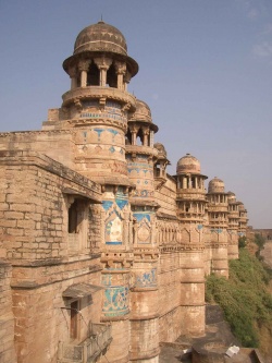
Gwalior is a city in Madhya Pradesh and the administrative headquarters of Gwalior District. It now includes the former city of Lashkar which was the capital of Gwalior princely state.
Military history
External links
- Gwalior Gazetteer 1857
Historical books online
- "Sindhia’s or Gwalior Territories" page 371 The Bengal and Agra Annual Guide and Gazetteer for 1842 Volume II Google Books
- Morar, Gwalior page 370 Report of the Commissioners Appointed to Inquire into the Sanitary State of the Army in India : with Abstract of Evidence, and of Reports Received from Indian Military Stations 1864 Archive.org