File:Nilgiri Mountain Railway Map with mileages and altitudes.png: Difference between revisions
Jump to navigation
Jump to search
'''Nilgiri Mountain Railway Map with mileages and altitudes''' Map from “Ascent to Ooty” by H C Hughes and P J Bawcutt, Railway Magazine November 1967 Vol 113 No 789 Transport and Technical Publications. The map is from this article with the milea... |
(No difference)
|
Latest revision as of 17:02, 17 November 2018
Summary
Nilgiri Mountain Railway Map with mileages and altitudes
Map from “Ascent to Ooty” by H C Hughes and P J Bawcutt, Railway Magazine November 1967 Vol 113 No 789 Transport and Technical Publications. The map is from this article with the mileages and altitudes extracted for clarity.
Licensing
|
|
This work is licensed under the Creative Commons Attribution 3.0 unported License. Specific Attribution: None specified Anyone may use this image for any purpose provided it is attributed as specified. |

File history
Click on a date/time to view the file as it appeared at that time.
| Date/Time | Thumbnail | Dimensions | User | Comment | |
|---|---|---|---|---|---|
| current | 17:01, 17 November 2018 | 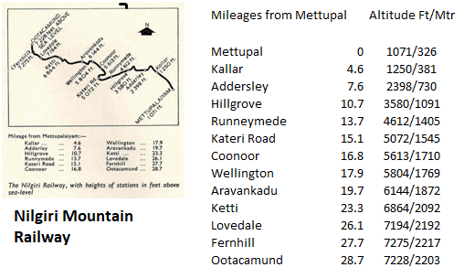 | 508 × 304 (107 KB) | PEA-2292 (talk | contribs) | '''Nilgiri Mountain Railway Map with mileages and altitudes''' Map from “Ascent to Ooty” by H C Hughes and P J Bawcutt, Railway Magazine November 1967 Vol 113 No 789 Transport and Technical Publications. The map is from this article with the milea... |
You cannot overwrite this file.
File usage
The following page uses this file: