| The Families In British India Society (FIBIS) is a self-help organisation devoted to members researching their British India family history and the background against which their ancestors led their lives in India under British rule. Let FIBIS help you break down those brick walls in your research |
Bahawalpur State: Difference between revisions
Jump to navigation
Jump to search
→Cities and Towns: fort |
area, population, towns and villages |
||
| (3 intermediate revisions by the same user not shown) | |||
| Line 4: | Line 4: | ||
|coordinates= | |coordinates= | ||
|altitude= | |altitude= | ||
|presentname= Bahawalpur/Rahim Yar Khan | |presentname= [http://en.wikipedia.org/wiki/Bahawalnagar_District Bahawalnagar District], [http://en.wikipedia.org/wiki/Bahawalpur_District Bahawalpur District], [http://en.wikipedia.org/wiki/Rahim_Yar_Khan_District Rahim Yar Khan District] | ||
|stateprovince= [ | |stateprovince= [http://en.wikipedia.org/wiki/Punjab_(Pakistan) Punjab] | ||
|country= Pakistan | |country= [http://en.wikipedia.org/wiki/Pakistan Pakistan] | ||
}} | }} | ||
Bahawalpur State was | '''Bahawalpur State''' was located in [[Punjab]]. | ||
==Capital== | ==Capital== | ||
* [[Bahawalpur]] | * [[Bahawalpur]] | ||
==Area== | |||
15,003 sq miles<ref> Census of India 1931 [http://censusindia.gov.in/Census_And_You/old_report/Census_1931_tebles.html]</ref> | |||
==Population== | |||
* 1931: 984,612<ref> Census of India 1931 [http://censusindia.gov.in/Census_And_You/old_report/Census_1931_tebles.html]</ref> | |||
==Towns and Villages== | |||
According to the 1931 Census, there were 2,376 towns and villages in the State.<ref> Census of India 1931 [http://censusindia.gov.in/Census_And_You/old_report/Census_1931_tebles.html]</ref> | |||
==History== | ==History== | ||
The State acceeded to Pakistan and formally merged in 1955. | It was ruled by the Abbassi family from 1748 to 1954. The State acceeded to Pakistan and formally merged in 1955. | ||
| Line 30: | Line 38: | ||
* [[Rahim Yar Khan]] | * [[Rahim Yar Khan]] | ||
* [[Sadiqabad]] | * [[Sadiqabad]] | ||
==Forts== | ==Forts== | ||
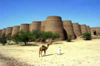
[[Image:Derawarfortbwp.jpg|thumb|200px| | [[Image:Derawarfortbwp.jpg|thumb|200px|right|Derawar Fort]] | ||
* Derawar Fort | * Derawar Fort | ||
==References== | |||
<references /> | |||
==External Links== | ==External Links== | ||
Latest revision as of 14:29, 13 May 2010
| Bahawalpur State | |
|---|---|

| |
| Presidency: | |
| Coordinates: | |
| Altitude: | |
| Present Day Details | |
| Place Name: | Bahawalnagar District, Bahawalpur District, Rahim Yar Khan District |
| State/Province: | Punjab |
| Country: | Pakistan |
| Transport links | |
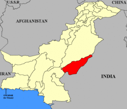
Bahawalpur State was located in Punjab.
Capital
Area
15,003 sq miles[1]
Population
- 1931: 984,612[2]
Towns and Villages
According to the 1931 Census, there were 2,376 towns and villages in the State.[3]
History
It was ruled by the Abbassi family from 1748 to 1954. The State acceeded to Pakistan and formally merged in 1955.
Present day divisions
Three districts, namely, Rahim Yar Khan, Bahawalpur and Bahawalnagar were formed out of this State.
Cities and Towns
Forts

- Derawar Fort