Rangoon: Difference between revisions
Jump to navigation
Jump to search
No edit summary |
Symorsebrown (talk | contribs) Amend summary, external links |
||
| Line 9: | Line 9: | ||
|transport= | |transport= | ||
}} | }} | ||
{{Places of Interest|title=Rangoon|name=Rangoon |link=xxxxx}} | |||
=====THIS PAGE IS WAITING FOR MORE DETAILED INFORMATION===== | |||
'''Rangoon''', in what was formerly known as Lower [[Burma]], was the capital of British Burma from 1885. | '''Rangoon''', in what was formerly known as Lower [[Burma]], was the capital of British Burma from 1885 and a separate district in Pegu Division during the British period. It was also the headquarters of [http://dsal.uchicago.edu/reference/gazetteer/pager.html?volume=13&objectid=DS405.1.I34_V13_032.gif Hanthawaddy District]. | ||
== History == | == History == | ||
Rangoon came under British rule in the 1850s and was transformed into a busy commercial port. It became the capital of British Burma after Upper Burma was captured in the [[3rd Burma War]], making overland access from the rest of British India possible. | Rangoon came under British rule in the 1850s and was transformed into a busy commercial port. It became the capital of British Burma after Upper Burma was captured in the [[3rd Burma War]], making overland access from the rest of British India possible. | ||
====Military history==== | |||
*[[Occupation of Rangoon]] 1824, part of the [[1st Burma War]] | *[[Occupation of Rangoon]] 1824, part of the [[1st Burma War]] | ||
*[[Battle of Rangoon]] 1852, part of the [[2nd Burma War]] | *[[Battle of Rangoon]] 1852, part of the [[2nd Burma War]] | ||
| Line 26: | Line 29: | ||
==External links== | ==External links== | ||
[http://www.1911encyclopedia.org/Rangoon Rangoon] Love to Know 1911<br> | |||
[http://dsal.uchicago.edu/reference/gazetteer/pager.html?objectid=DS405.1.I34_V21_219.gif Rangoon City] Imperial Gazetteer<br> | |||
*[http://www.flickr.com/photos/23268776@N03/2343526806/ Holy Trinity Cathedral - Rangoon – 1886] flickr.com | *[http://www.flickr.com/photos/23268776@N03/2343526806/ Holy Trinity Cathedral - Rangoon – 1886] flickr.com | ||
Revision as of 16:45, 19 June 2012
| Rangoon | |
|---|---|
| [[Image:|250px| ]] | |
| Presidency: Bengal Presidency | |
| Coordinates: | 16.868878°N 96.236255°E |
| Altitude: | |
| Present Day Details | |
| Place Name: | Yangon |
| State/Province: | Yangon Division |
| Country: | Burma |
| Transport links | |
| FibiWiki Maps | |
|---|---|
| See our interactive map of this location showing places of interest during the British period | |
| [xxxxx Rangoon] |
THIS PAGE IS WAITING FOR MORE DETAILED INFORMATION
Rangoon, in what was formerly known as Lower Burma, was the capital of British Burma from 1885 and a separate district in Pegu Division during the British period. It was also the headquarters of Hanthawaddy District.
History
Rangoon came under British rule in the 1850s and was transformed into a busy commercial port. It became the capital of British Burma after Upper Burma was captured in the 3rd Burma War, making overland access from the rest of British India possible.
Military history
- Occupation of Rangoon 1824, part of the 1st Burma War
- Battle of Rangoon 1852, part of the 2nd Burma War
Spelling Variants
Modern name: Yangon
Variants: Rangoon
Maps
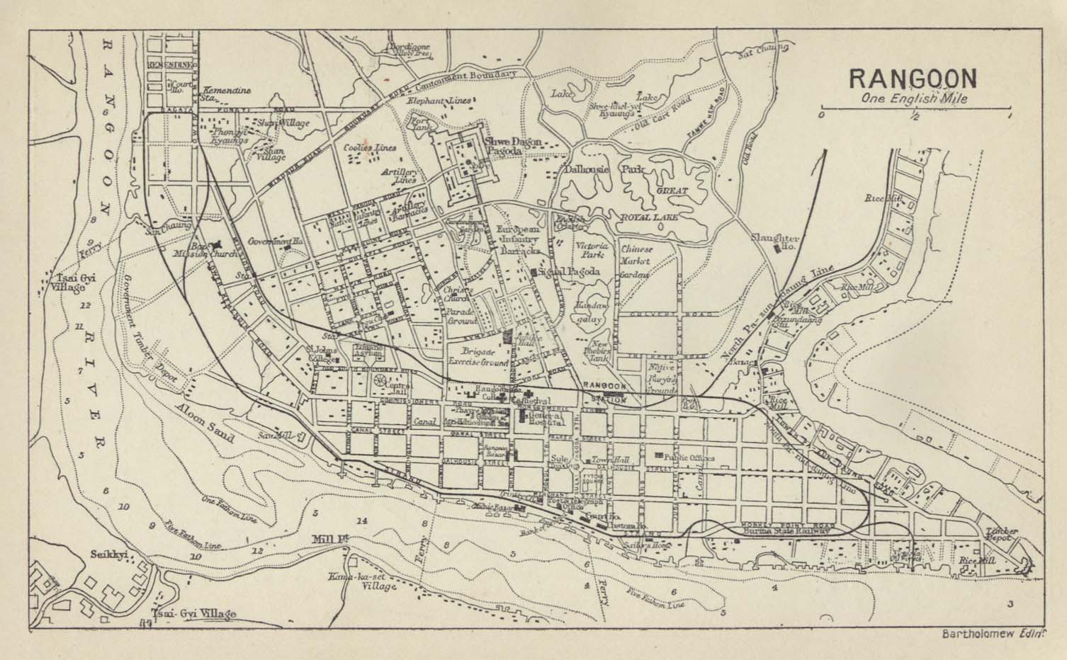
- Map of Rangoon 1912 from the Historical Maps of Asia Collection, University of Texas, Austin
External links
Rangoon Love to Know 1911
Rangoon City Imperial Gazetteer
- Holy Trinity Cathedral - Rangoon – 1886 flickr.com