Ghora Gali: Difference between revisions
Jump to navigation
Jump to search
image |
province |
||
| Line 5: | Line 5: | ||
|altitude= 1,691 m (5,500 ft) | |altitude= 1,691 m (5,500 ft) | ||
|presentname= [http://en.wikipedia.org/wiki/Ghora_Gali Ghora Gali] | |presentname= [http://en.wikipedia.org/wiki/Ghora_Gali Ghora Gali] | ||
|stateprovince= [http://en.wikipedia.org/wiki/ | |stateprovince= [http://en.wikipedia.org/wiki/Punjab Punjab] | ||
|country= [http://en.wikipedia.org/wiki/Pakistan Pakistan] | |country= [http://en.wikipedia.org/wiki/Pakistan Pakistan] | ||
}} | }} | ||
'''Ghora Gali''' was a hill station, located | '''Ghora Gali''' was a hill station, located close to [[Murree]], another hill station in [[Punjab]]. | ||
Revision as of 17:50, 7 November 2011
| Ghora Gali | |
|---|---|
| [[Image:|250px| ]] | |
| Presidency: Bengal | |
| Coordinates: | 33.83, 73.35 |
| Altitude: | 1,691 m (5,500 ft) |
| Present Day Details | |
| Place Name: | Ghora Gali |
| State/Province: | Punjab |
| Country: | Pakistan |
| Transport links | |
Ghora Gali was a hill station, located close to Murree, another hill station in Punjab.
Education
- One of the Lawrence Military Asylums (now Lawrence College) was founded here in 1860 to provide education for the orphans of British soldiers in India.
Business

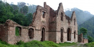
- The Murree Brewery was estalished here in 1860. There is a contemporary photograph of the brewery held in the Bellew Collection at the British Library. The building was destroyed during the Partition riots in 1947. However, the business still exists with its office in Rawalpindi.
Externall Links
- Ghora Gali Wikipedia.