Pondicherry: Difference between revisions
Jump to navigation
Jump to search
m image added |
|||
| Line 1: | Line 1: | ||
{{Locations_Infobox | {{Locations_Infobox | ||
|presidency=[[Madras]] | |presidency=[[Madras]] | ||
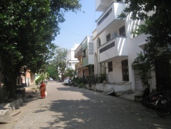
|image= | |image=Pondicherry - French sector.JPG | ||
|coordinates=[http://maps.google.co.uk/maps?ll=11.845116,79.875241&z=9&t=h&hl=en 11.845116°N 79.875241°E] | |coordinates=[http://maps.google.co.uk/maps?ll=11.845116,79.875241&z=9&t=h&hl=en 11.845116°N 79.875241°E] | ||
|altitude= 0 m (0 ft) | |altitude= 0 m (0 ft) | ||
Revision as of 08:12, 15 December 2011
| Pondicherry | |
|---|---|

| |
| Presidency: Madras | |
| Coordinates: | 11.845116°N 79.875241°E |
| Altitude: | 0 m (0 ft) |
| Present Day Details | |
| Place Name: | Puducherry |
| State/Province: | Indian Union Territory of Puducherry |
| Country: | India |
| Transport links | |
| Pondicherry Railway | |
Pondicherry was formerly a French colony founded by Francois Martin in 1674.
History
- Siege of Pondicherry 1748
- Capture of Pondicherry 1761
- Battle of Pondicherry 1778
- Battle of Pondicherry 1793
Records
- See French
External links
- Jean-Claude Féray has compiled an excellent series of webpages on French genealogy in Pondicherry, which are now archived. The site is in French, but the lists of names will be comprehensible to non-French-speakers. Here are some of them:
- This India List post says that the Pondicherry archives are in the "Centre des Archives d'Outre-Mer" (CAOM) in the city of Aix en Provence, France
- "Pondicherry – A bit of France in India" by Sunayana Panda confluence.org.uk