| The Families In British India Society (FIBIS) is a self-help organisation devoted to members researching their British India family history and the background against which their ancestors led their lives in India under British rule. Let FIBIS help you break down those brick walls in your research |
Seringapatam: Difference between revisions
Jump to navigation
Jump to search
Symorsebrown (talk | contribs) Add internal link |
No edit summary |
||
| Line 20: | Line 20: | ||
== External links == | == External links == | ||
[http://en.wikipedia.org/wiki/Seringapatam Srirangapatna] Wikipedia | *[http://en.wikipedia.org/wiki/Seringapatam Srirangapatna] Wikipedia | ||
===Historical books online=== | |||
*[https://archive.org/details/SeringapatamConstanceParsons1931 ''Seringapatam''] [A Guide Book] by Constance E Parsons 1931 Archive.org | |||
[[Category:Locations]] | [[Category:Locations]] | ||
[[Category:Cities, towns and villages in Madras Presidency]] | [[Category:Cities, towns and villages in Madras Presidency]] | ||
Revision as of 08:32, 5 June 2015
| Seringapatam | |
|---|---|

| |
| Presidency: Madras | |
| Coordinates: | 12.418346°N 76.695989°E |
| Altitude: | 679 m (2,228 ft) |
| Present Day Details | |
| Place Name: | Srirangapatna |
| State/Province: | Karnataka |
| Country: | India |
| Transport links | |
| Mysore State Railway | |
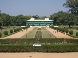
Seringapatam was in the State of Mysore and the town (now Srirangapatna) is an important place of pilgrimage. It was the capital of Hyder Ali and his son, Tipu Sultan, and also the location of the last and decisive battle in 1799 between Tipu and the British.
History
Siege of Seringapatam 1792
Battle of Seringapatam 1799
Spelling Variants
Modern name:Srirangapatnam, Srirangapattana
Variants: Seringapatam, Srirangapatna, Srirangapattang
External links
- Srirangapatna Wikipedia
Historical books online
- Seringapatam [A Guide Book] by Constance E Parsons 1931 Archive.org