Naini Tal
| Naini Tal | |
|---|---|

| |
| Presidency: Bengal | |
| Coordinates: | 29.38°N, 79.45°E |
| Altitude: | 2,084 m (6,837 ft) |
| Present Day Details | |
| Place Name: | Nainital |
| State/Province: | Uttarakhand |
| Country: | India |
| Transport links | |
| FibiWiki Maps | |
|---|---|
| See our interactive map of this location showing places of interest during the British period | |
| [xxxxx Naini Tal] |
THIS PAGE IS WAITING FOR MORE DETAILED INFORMATION
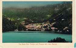
Naini Tal, a hill station in the Kumaon foothills of the outer Himalayas, was the headquarters of Naini Tal District in the Kumaon Division of United Provinces during the British period. A cantonment was located there.
Spelling Variants
Modern name: Nainital
Variants: Nynee Tal/Naini Tal
Surrounding area
Bhim Tal , modern name Bhimtal (Wikipedia) is situated 22 kilometres from Naini Tal . It was the location of a Boer prisoner of war camp , established in 1902 at the north end of the lake, according to this link[1]
Approximately 65 kilometres (40 miles) from Nainital is the Jim Corbett National Park The author of this India List post has happy memories of her young days in the forests of Kumaon near the Jim Corbett National Park.
FIBIS Resources
- Images of Nainital
- Images of Nainital FIBIS Gallery
Schools

Oak Openings Boys High School was renamed in 1889, when it was relocated from a previous site. Jim Corbett of Jim Corbett National Park fame attended this school. In 1905 the Philander Smith Institute of Mussoorie, founded by a Mrs. Smith, widow of Mr. Philander Smith of Illinois was moved to Nainital and "amalgamated" with the Oak Openings Boys’ High School and the result was the Philander Smith College [2].
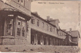
"In the latter half of the 19th century, a number of “European” schools were founded in Nainital for British boys and girls. By 1906, there were over half a dozen such schools, including the Diocesan Boys’ School (later renamed Sherwood College) under the guidance of the Church of England; Philander Smith’s College (now Birla Vidya Mandir), maintained by an American; St. Joseph’s College, a Roman Catholic institution; Wellesley School, an American institution; St. Mary’s Convent High School, a Roman Catholic institution; All Saints Diocesan High School for Girls, under the Church of England, and Petersfield College for Girls. In the 1920s and 30s, the schools began to admit more Indian students."[3]
The Philander Smith College disappears from the scene in the early forties, probably due to the Second World War. The deserted campus of the college was now to be occupied by the short lived Hallet War School of the early forties named after the last Governor of the then United Province. [2]
Churches
- St John in the Wilderness (established 1884)
Cemeteries
- St John in the Wilderness (1845-1928) ( Some information can be found in BACSA file British Library ref MSS Eur F370/603)
- Victims of the 1880 LandslipBurials at St John in the Wilderness - P211 List of inscriptions on Christian tombs and tablets of historical interest in the United Provinces of Agra and Oudh by E A H Blunt ICS 1911 Archive.org
- Pines Cemetery
Some information on the following three cemeteries can be found in BACSA file in the British Library (ref Mss Eur F370/604)
- Haldwani Cemetery (Muslim Graveyard)
- Kaladungi Cemetery India List Post 1998 states some graves date back to 1870s.
- Methodist Cemetery (Ayarpatta)
Volunteer Regiment
External links
- Naini Tal Town Imperial Gazetteer
- Nainital Tourism
- History of Nainital
- Churches in In & Around Nainital District Includes St John In The Wilderness Church
- Rare Old British Era Picture Gallery Of Nainital
- Photograph of St. John's Church, Nainital apparently now derelict. trekearth.com
- History of Naini Tal gurneyhouse.com
- Terrible Landslip In India Nelson Evening Mail, Volume XV, Issue 236, 26 November 1880, page 4 paperspast.natlib.govt.nz
- Birla Vidyamandir School: History
- History of Sherwood College, originally the Nainital Diocesan Boys School, founded 1867. oldsherwoodians.com, the Sherwood Alumni website.
- History of St. Joseph's College, Nainital
- Photograph by Samuel Bourne - Lake, Nynee Tal, 1860 flickr.com
Historical books online
- "Naini Tal Town" Imperial Gazetteer of India, Volume 18, page 333.
- "Map of Naini Tal", between pages 282 and 283, A Handbook for Travellers in India, Burma, and Ceylon published by John Murray, London Eighth Edition 1911 Archive.org.
- "Nynee Tal" from "A Sketch of the Physical and Topographical Characters and Other Relations of the Hill Sanitaria of Darjeeling, Nynee Tal, Landour and Murree, in the Bengal Presidency", page 307 Army Medical Department: Report for the Year 1862 Google Books
- My India by Jim Corbett originally published 1952 Archive.org. Includes some descriptions of Naini Tal. For more books by Jim Corbett, see Kumaon
- The Himalayan Gazetteer or the Himalayan Districts of the North Western Province of India by Edwin T Atkinson in 3 Volumes (6 Parts) originally published 1882, 1884, 1886 is available, in a reprint edition, to read online on the Digital Library of India website. Covers the regions of Kumaon and Garhwal. Volume 1, Part 1 Contents computer page 12; Volume 1, Part 2 Contents cp 12, Index cp 536; Volume 2, Part 1 Contents cp18; Volume 2, Part 2 Contents cp 16 Index cp 458, includes History of the British in the area; Volume 3, Part 1 Contents cp 10 Place names A-J; Volume 3, Part 2 Contents cp 8 Place names K-Z.
- District Gazetteers of the United Provinces of Agra and Oudh: Volume 34: Nainital 1904 may be downloaded as a pdf from Bhagirathi - The Institute Repository of IIT Roorkee
References
- ↑ Page 78 Hill resorts of U.P. Himalaya,: a geographical study by Nutan Tyagi 1991 Google Books
- ↑ 2.0 2.1 Birla Vidyamandir School: History
- ↑ History of Naini Tal gurneyhouse.com