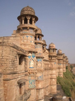
Gwalior
| Gwalior | |
|---|---|

| |
| Presidency: Bengal | |
| Coordinates: | 26.229876°N 78.16924°E |
| Altitude: | 196 m (643 ft) |
| Present Day Details | |
| Place Name: | Gwalior |
| State/Province: | Madhya Pradesh |
| Country: | India |
| Transport links | |
| North Central Railway Gwalior Light Railway | |
'Gwaliorwas the the administrative headquarters of Gwalior District during the British period. It now includes the former city of Lashkar which was the capital of Gwalior princely state.
Military history
External links
- Gwalior City Imperial Gazetteer
Historical books online
- "Sindhia’s or Gwalior Territories" page 371 The Bengal and Agra Annual Guide and Gazetteer for 1842 Volume II Google Books
- General Sir Richard Meade and the Feudatory States of Central and Southern India; a record of forty-three year's service as Soldier, Political Officer and Administrator by Thomas Henry Thornton 1898 Archive.org. Born 1821, Sir Richard served in the Bengal Army from 1838 for nearly twenty years. At the outbreak of the Indian Mutiny he was Brigade-Major of the Gwalior Contingent which mutinied. He later raised Meade’s Horse. Subsequently in 1859 he was appointed Political Agent at Gwalior, then two years later Governor-General’s Agent for the States of Central India, the first of several important posts, involving many confidential matters, finally retiring in March 1881.
- Morar, Gwalior page 370 Report of the Commissioners Appointed to Inquire into the Sanitary State of the Army in India : with Abstract of Evidence, and of Reports Received from Indian Military Stations 1864 Archive.org