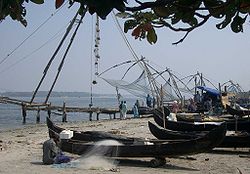
Cochin
| Cochin | |
|---|---|

| |
| Presidency: Madras | |
| Coordinates: | 9.9509843°N 76.251649°E |
| Altitude: | |
| Present Day Details | |
| Place Name: | Kochi |
| State/Province: | Kerala |
| Country: | India |
| Transport links | |
| FibiWiki Maps | |
|---|---|
| See our interactive map of this location showing places of interest during the British period | |
| Cochin |
Cochin (now called Kochi) is a city in the modern state of Kerala. In the British era it was part of the Madras (Presidency). Kochi City comprises three municipalities in the Cochin area: Fort Cochin, Mattancherry and Ernakulam. Ernakulam is the largest urban area.
History
Cochin became the site of the earliest European settlement in India when the Portuguese landed in 1500. The Kingdom of Cochin (see Cochin State) agreed friendly relations with the Portuguese, who cemented their involvement in the city by winning a war with the rulers of Calicut. Although the Raja of Cochin was nominally in charge, the Portuguese effectively ruled the city from 1503-1663. The Dutch then conquered Cochin and ruled the territory until 1773 when Hyder Ali took possession. In 1814, the British acquired Cochin under the Anglo-Dutch Treaty in exchange for the island of Banca (in Indonesia).
Fort Cochin area
Built around the old Portuguese Fort Emmanuel, this area is the oldest part of Cochin, with Portuguese, Dutch and British buildings.
- "New life for a monument" by Priyadershini S. The Hindu Kochi, March 3, 2013. The historic Bastion Bungalow in Fort Kochi will become a Heritage Museum.
- Slideshow: A peek into India's enduring maritime history Photographs by K.K. Mustafah. The Southern Naval Command’s Maritime Museum, located at Fort Kochi, hosts a variety of exhibits tracing the origin and evolution of the Indian Navy. The Hindu May 21, 2013
Churches
External links
- Wikipedia:
- British capture of Fort Cochin Google Books
- The Dutch Cemetery Fort Cochin thefortcochin.blogspot
- Dutch Cemetery Fort Kochi by keralatourism YouTube
- Dutch cemetery- Kochi City Time Aug 09, 2011 part 2 YouTube. Not in English.
- This India List post about mixed marriages mentions Cochin
- "Lost rulers of the Malabar Coast" by N P Chekkutty 10 December 2012 himalmag.com. "Tales of love and loss from the heyday of Portuguese rule in Kochi".
- "Step into history": Jew Street, Mattancherry, Cochin by Priyadershini S. December 20, 2012 The Hindu. Also see the page Jewish
- Mattancherry’s 463-year-old synagogue now a cattle shed by Nidhi Surendranath September 14, 2013 The Hindu Kochi
- The cuisine connection by Esther Elias December 12, 2013 The Hindu Kochi. Food of Cochini Jews
- Jewish Cemetery Kochi by keralatourism YouTube
- Archives Department Government of Kerala Records of the Cochin State (AD 1567-1949) are available at the Regional Archives, Ernakulam
- "They landed here…" by Arun Bhatia The Hindu March 1, 2013. Mentions the small port called Cranganore by the British, 35km from Cochin
- The Gothic landmark by Esther Elias December 23, 2013 The Hindu Kochi. St. Albert’s Higher Secondary School was begun by the Carmelite Missionaries. The two Gothic red buildings were built between 1892 and 1897.
Historical books online
- British and Native Cochin by Charles Allen Lawson 2nd edition 1861 Google Books. First published 1860
- The land of the Permauls: or Cochin, its past and its present by Francis Day 1863 Google Books
- "Kingdom of Cochin" page 156 A description of the coasts of East Africa and Malabar in the beginning of the sixteenth century by Duarte Barbosa, a Portuguese. Translated from an early Spanish manuscript in the Barcelona library with notes and a preface by Henry E. J. Stanley. 1866 Archive.org