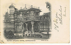
Ahmadabad
| Ahmadabad | |
|---|---|

| |
| Presidency: Bombay | |
| Coordinates: | 23°01'48.0"N 72°34'48.0"E |
| Altitude: | 53 m (174 ft) |
| Present Day Details | |
| Place Name: | Ahmedabad |
| State/Province: | Gujarat |
| Country: | India |
| Transport links | |
| Bombay, Baroda and Central India Railway Ahmedabad-Dholka Railway Ahmedabad-Parantij Railway | |
| FibiWiki Maps | |
|---|---|
| See our interactive map of this location showing places of interest during the British period | |
| Ahmadabad |
Ahmadabad, to the north-west of Baroda, was the headquarters of Ahmadabad District in Bombay Province during the British period. It was the second largest city in the Presidency of Bombay. It is now the largest city in the state of Gujarat.
There was a cantonment, located 3½ miles north of the city.
Spelling Variants
Modern name: Ahmedabad
Variants: Ahmadabad
History
During the 1st Maratha War, General Goddard captured the city in the Battle of Ahmadabad. Subsequently restored to the Marathas, it again came under British rule in 1818.
Records
Family Search has a series of images "India, Gujarat Diocese Protestant Church Records, 1854-2012" with details in this FamilySearch Research Wiki page. Some of the records are in the Hindi and Gujarati languages, but there are some records in English, as evidenced by one of the sample records shown. It is probable that most of the older records, where they exist, are in English. A further example is this page of 1856 deaths at Ahmedabad.
Transport
Ahmedabad was the northern end of the original section of the Bombay, Baroda and Central India Railway which ran south via Baroda to Surat. By 1905, two metre gauge branch lines also originated at Ahmedabad.
External links
- Ahmadabad Imperial Gazetteer
Historical books online
- Architecture at Ahmedabad, the Capital of Goozerat Text by Sir Theodore Cracraft Hope, James Fergusson. Photographed by Colonel Biggs, RA 1866 Google Books