Difference between revisions of "Ajmer"
m (remove broken link) |
(→Railway workshops and colony) |
||
| (14 intermediate revisions by 3 users not shown) | |||
| Line 1: | Line 1: | ||
{{Locations_Infobox | {{Locations_Infobox | ||
|presidency=[[Bengal (Presidency)|Bengal]] | |presidency=[[Bengal (Presidency)|Bengal]] | ||
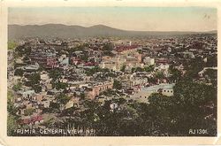
| − | |image= | + | |image=Ajmir - General View.jpg |
|coordinates= [http://maps.google.co.uk/maps?ll=26.441,74.641&z=12&t=h&hl=en 26.441°N 74.641°E] | |coordinates= [http://maps.google.co.uk/maps?ll=26.441,74.641&z=12&t=h&hl=en 26.441°N 74.641°E] | ||
|altitude= 486 m (1,594 ft) | |altitude= 486 m (1,594 ft) | ||
| Line 9: | Line 9: | ||
|transport=[[Rajputana-Malwa State Railway]]<br>[[Bombay, Baroda and Central India Railway]]}} | |transport=[[Rajputana-Malwa State Railway]]<br>[[Bombay, Baroda and Central India Railway]]}} | ||
{{Places of Interest|title=Ajmer|name=Ajmer|link=xxxxx}} | {{Places of Interest|title=Ajmer|name=Ajmer|link=xxxxx}} | ||
| − | |||
'''Ajmer City''' was the administrative headquarters of Ajmer District in the province of [http://dsal.uchicago.edu/reference/gazetteer/pager.html?objectid=DS405.1.I34_V05_145.gif Ajmer-Merwara]. It is now the largest city in Rajasthan. | '''Ajmer City''' was the administrative headquarters of Ajmer District in the province of [http://dsal.uchicago.edu/reference/gazetteer/pager.html?objectid=DS405.1.I34_V05_145.gif Ajmer-Merwara]. It is now the largest city in Rajasthan. | ||
| Line 15: | Line 14: | ||
==Spelling variants== | ==Spelling variants== | ||
Modern name: Ajmer<br> | Modern name: Ajmer<br> | ||
| − | Variants: Ajmere/Ajaymeru | + | Variants: Ajmere / Ajaymeru / Ajmeer |
| − | == | + | ==Also see== |
| − | [[Ajmer-Merwara Districts]] | + | *[[Ajmer-Merwara Districts]] |
| + | *[[Mhairwara Battalion]] also known as the Merwara Regiment. | ||
| + | *[[Ajmer Regiment]], a [[Second World War]] regiment. | ||
==Army== | ==Army== | ||
There was a cantonment at Ajmer, and elsewhere in the province at [[Nasirabad]] (14 miles away) and Deoli. Further details are given in this [http://dsal.uchicago.edu/reference/gazetteer/pager.html?objectid=DS405.1.I34_V05_173.gif link]<ref> | There was a cantonment at Ajmer, and elsewhere in the province at [[Nasirabad]] (14 miles away) and Deoli. Further details are given in this [http://dsal.uchicago.edu/reference/gazetteer/pager.html?objectid=DS405.1.I34_V05_173.gif link]<ref> | ||
[http://dsal.uchicago.edu/reference/gazetteer/pager.html?objectid=DS405.1.I34_V05_173.gif "Army: Ajmer- Merwara Province"] ''Imperial Gazetteer of India, Volume 5'', page 165.</ref> | [http://dsal.uchicago.edu/reference/gazetteer/pager.html?objectid=DS405.1.I34_V05_173.gif "Army: Ajmer- Merwara Province"] ''Imperial Gazetteer of India, Volume 5'', page 165.</ref> | ||
| + | |||
| + | C 1859, there was a detachment of the Mhairwarrah (Mharwarrah, Mharwarra) Battalion , a Local Infantry or Irregular Corps, stationed at Ajmere.<ref>[http://books.google.com.au/books?id=DPY2AQAAMAAJ&pg=PA249 Page 249] ''Quarterly Army List of Her Majesty's British Forces on the Bengal Establishment'' 1859 Google Books</ref> There were also troops of the Battalion at Bewar (Bewur) which is possibly in the vicinity. | ||
| + | |||
| + | ===Volunteers=== | ||
| + | "Ajmer is the head-quarters of the 2nd Battalion, [[Bombay, Baroda and Central India Railway Regiment |Bombay, Baroda and Central India Railway Volunteer Rifles]]. The corps originally formed part of the Agra Volunteer Rifle Corps, with the title of Rajputana-Malwa Volunteer Rifle Corps. In 1887 its title was changed to the present designation. It consists of 11 companies, including a cadet company at Mount Abu. Its strength in 1903 stood at 344".<ref> [https://archive.org/stream/rajputanadistri00agegoog#page/n141/mode/2up Page 122] ''Rajputana District Gazetteers: Volume I-A Ajmer Merwara'' by C C Watson, ICS 1904 Archive.org</ref> | ||
| + | |||
| + | ==Railway workshops and colony== | ||
| + | Ajmer, and [[Jamalpur]] workshops manufactured more than 500 broad and narrow gauge steam locomotives between 1895 and 1920. <ref> | ||
| + | [http://www.independent.co.uk/news/world/the-last-gasp-for-indias-age-of-steam-drivers-mourn-locomotives-that-united-a-nation-1468307.html “The last gasp for India's age of steam: Drivers mourn locomotives that united a nation”] 23 October 2011 independent.co.uk</ref> | ||
| + | |||
| + | There was a large railway colony, with a hospital at Ajmer. It was one of those railway colonies along the [[Bombay, Baroda and Central India Railway]] whose Railway Institute dances were so well regarded that people would travel for up to six hours by train to attend.<ref>[https://web.archive.org/web/20201101231007/https://www.thestatesman.com/supplements/the-anglo-indian-legacy-saga-106491.html "The Anglo-Indian legacy saga"] by R V Smith Nov 26 2015 ''The Statesman'', now archived. </ref> | ||
==External links== | ==External links== | ||
*[http://archiseek.com/2009/1879-mayo-college-ajmer-india/ 1879-Mayo College, Ajmer] archiseek.com | *[http://archiseek.com/2009/1879-mayo-college-ajmer-india/ 1879-Mayo College, Ajmer] archiseek.com | ||
| − | *[http://www.gpmsdbaweb.com/memoir2/LifeinIndia/Ajmer_1933_1940(1).htm Ajmer 1933-40] Life in a railway colony from [http://www.gpmsdbaweb.com/memoir2/ An Indian Childhood] by Eugene Blanchette born 1933 | + | *[https://web.archive.org/web/20150919014907/http://www.gpmsdbaweb.com/memoir2/LifeinIndia/Ajmer_1933_1940(1).htm Ajmer 1933-40] Life in a railway colony from [https://web.archive.org/web/20150426070344/http://www.gpmsdbaweb.com/memoir2/ An Indian Childhood], now archived, by Eugene Blanchette born 1933. |
| − | *[ | + | *[https://www.theguardian.com/lifeandstyle/2011/oct/22/pindia-rajasthan-british-raj "My Indian summer"] The author’s mother lived in Ajmer, where her father was a senior railway foreman, until Independence. www.guardian.co.uk 22 October 2011 |
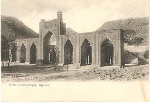
| + | [[Image:Ajmere - Arhai-Din-Ka-Ihopra 001.jpg|thumb|right|300px| Ajmere -Arhai-Din-Ka-Jhopra]] | ||
====Historical books online==== | ====Historical books online==== | ||
*[http://dsal.uchicago.edu/reference/gazetteer/pager.html?objectid=DS405.1.I34_V05_178.gif "Ajmer City"] ''Imperial Gazetteer of India, Volume 5'', page 170. | *[http://dsal.uchicago.edu/reference/gazetteer/pager.html?objectid=DS405.1.I34_V05_178.gif "Ajmer City"] ''Imperial Gazetteer of India, Volume 5'', page 170. | ||
*[http://dsal.uchicago.edu/reference/gazetteer/pager.html?objectid=DS405.1.I34_V05_145.gif "Ajmer-Merwara Province"]. ''Imperial Gazetteer of India, Volume 5'', page 137. | *[http://dsal.uchicago.edu/reference/gazetteer/pager.html?objectid=DS405.1.I34_V05_145.gif "Ajmer-Merwara Province"]. ''Imperial Gazetteer of India, Volume 5'', page 137. | ||
| − | + | *[http://books.google.com.au/books?id=kFQOAAAAQAAJ&pg=PP7 ''Some Account of the General and Medical Topography of Ajmeer''] by Assistant Surgeon Robert Hamilton Irvine 1841 Google Books | |
| + | *[https://archive.org/details/in.gov.ignca.14910/page/n1/mode/2up ''Ajmer Historical And Descriptive''] by Har Bilas Sarda. 1911. Missing title page. [https://archive.org/details/in.ernet.dli.2015.213052/mode/2up 2nd file, with title page]. Archive.org. [https://archive.org/details/in.ernet.dli.2015.122657/page/n1/mode/2up 1941 reprint edition, rewritten and enlarged], Archive.org mirror from Digital Library of India. | ||
==References== | ==References== | ||
<references/> | <references/> | ||
Latest revision as of 22:26, 7 October 2022
| Ajmer | |
|---|---|

| |
| Presidency: Bengal | |
| Coordinates: | 26.441°N 74.641°E |
| Altitude: | 486 m (1,594 ft) |
| Present Day Details | |
| Place Name: | Ajmer |
| State/Province: | Rajasthan |
| Country: | India |
| Transport links | |
| Rajputana-Malwa State Railway Bombay, Baroda and Central India Railway | |
| FibiWiki Maps | |
|---|---|
| See our interactive map of this location showing places of interest during the British period | |
| [xxxxx Ajmer] |
Ajmer City was the administrative headquarters of Ajmer District in the province of Ajmer-Merwara. It is now the largest city in Rajasthan.
Contents
Spelling variants
Modern name: Ajmer
Variants: Ajmere / Ajaymeru / Ajmeer
Also see
- Ajmer-Merwara Districts
- Mhairwara Battalion also known as the Merwara Regiment.
- Ajmer Regiment, a Second World War regiment.
Army
There was a cantonment at Ajmer, and elsewhere in the province at Nasirabad (14 miles away) and Deoli. Further details are given in this link[1]
C 1859, there was a detachment of the Mhairwarrah (Mharwarrah, Mharwarra) Battalion , a Local Infantry or Irregular Corps, stationed at Ajmere.[2] There were also troops of the Battalion at Bewar (Bewur) which is possibly in the vicinity.
Volunteers
"Ajmer is the head-quarters of the 2nd Battalion, Bombay, Baroda and Central India Railway Volunteer Rifles. The corps originally formed part of the Agra Volunteer Rifle Corps, with the title of Rajputana-Malwa Volunteer Rifle Corps. In 1887 its title was changed to the present designation. It consists of 11 companies, including a cadet company at Mount Abu. Its strength in 1903 stood at 344".[3]
Railway workshops and colony
Ajmer, and Jamalpur workshops manufactured more than 500 broad and narrow gauge steam locomotives between 1895 and 1920. [4]
There was a large railway colony, with a hospital at Ajmer. It was one of those railway colonies along the Bombay, Baroda and Central India Railway whose Railway Institute dances were so well regarded that people would travel for up to six hours by train to attend.[5]
External links
- 1879-Mayo College, Ajmer archiseek.com
- Ajmer 1933-40 Life in a railway colony from An Indian Childhood, now archived, by Eugene Blanchette born 1933.
- "My Indian summer" The author’s mother lived in Ajmer, where her father was a senior railway foreman, until Independence. www.guardian.co.uk 22 October 2011
Historical books online
- "Ajmer City" Imperial Gazetteer of India, Volume 5, page 170.
- "Ajmer-Merwara Province". Imperial Gazetteer of India, Volume 5, page 137.
- Some Account of the General and Medical Topography of Ajmeer by Assistant Surgeon Robert Hamilton Irvine 1841 Google Books
- Ajmer Historical And Descriptive by Har Bilas Sarda. 1911. Missing title page. 2nd file, with title page. Archive.org. 1941 reprint edition, rewritten and enlarged, Archive.org mirror from Digital Library of India.
References
- ↑ "Army: Ajmer- Merwara Province" Imperial Gazetteer of India, Volume 5, page 165.
- ↑ Page 249 Quarterly Army List of Her Majesty's British Forces on the Bengal Establishment 1859 Google Books
- ↑ Page 122 Rajputana District Gazetteers: Volume I-A Ajmer Merwara by C C Watson, ICS 1904 Archive.org
- ↑ “The last gasp for India's age of steam: Drivers mourn locomotives that united a nation” 23 October 2011 independent.co.uk
- ↑ "The Anglo-Indian legacy saga" by R V Smith Nov 26 2015 The Statesman, now archived.
