Difference between revisions of "Attock"
Jump to navigation
Jump to search
Symorsebrown (talk | contribs) m (Layout) |
m (Images added) |
||
| Line 1: | Line 1: | ||
{{Locations_Infobox | {{Locations_Infobox | ||
|presidency= [[Bengal (Presidency)|Bengal]] | |presidency= [[Bengal (Presidency)|Bengal]] | ||
| − | |image= | + | |image=Attock Bridge 2.jpg |
|coordinates=[http://maps.google.co.uk/maps?ll=33.8936,72.2414&z=14&t=h&hl=en 33.8936°N 72.2414°E] | |coordinates=[http://maps.google.co.uk/maps?ll=33.8936,72.2414&z=14&t=h&hl=en 33.8936°N 72.2414°E] | ||
|altitude= 346 m (1,138 ft) | |altitude= 346 m (1,138 ft) | ||
| Line 25: | Line 25: | ||
==Bridges== | ==Bridges== | ||
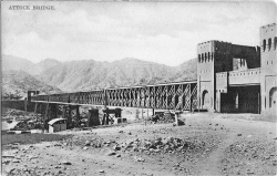
| + | [[Image:Attock Bridge.jpg|right|thumb|275px|''Attock Bridge With Running Train'']] | ||
A railway bridge designed by Sir Guildford Molesworth (1828-1925), was opened in 1883.<ref>[http://pakistaniat.com/2009/02/03/railway-bridge-on-indus-at-attock/ Railway bridge on Indus at Attock] All Things Pakistan</ref> | A railway bridge designed by Sir Guildford Molesworth (1828-1925), was opened in 1883.<ref>[http://pakistaniat.com/2009/02/03/railway-bridge-on-indus-at-attock/ Railway bridge on Indus at Attock] All Things Pakistan</ref> | ||
Revision as of 22:29, 6 February 2012
| Attock | |
|---|---|

| |
| Presidency: Bengal | |
| Coordinates: | 33.8936°N 72.2414°E |
| Altitude: | 346 m (1,138 ft) |
| Present Day Details | |
| Place Name: | Attock Khurd |
| State/Province: | Punjab |
| Country: | Pakistan |
| Transport links | |
For the city, Attock, see Campbellpur.
Attock was a small town on the banks of the River Indus in Attock District, Punjab. The district was named after this town rather than the capital city. A bridge over the River Indus was built here.
Contents
Spelling variants
Modern name: Attock Khurd
Variants: Attock
Transport
Railways
Railway Station
Roads
The Grand Truck (GT) Road passes the town.
Bridges
A railway bridge designed by Sir Guildford Molesworth (1828-1925), was opened in 1883.[1]
External Links
- Railway bridge on Indus at Attock All Things Pakistan
- Photographs of the Bridge and railway station Indian Railways Fan Club
References
- ↑ Railway bridge on Indus at Attock All Things Pakistan
