File list
Jump to navigation
Jump to search
This special page shows all uploaded files.
| Date | Name | Thumbnail | Size | Description |
|---|---|---|---|---|
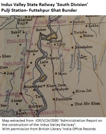
| 14:29, 21 January 2018 | Indus Valley State Railway 'South Division' Pulji Station-Futtehpur Ghat Bunder.png (file) |  |
263 KB | '''Indus Valley State Railway 'South Division' Pulji Station-Futtehpur Ghat Bunder''' Map section from British Library IOR/V/24/2359 "Administration Report on the construction of the Indus Valley Railway - Appendix" Reproduced by permission of ‘The... |
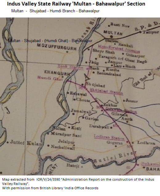
| 14:01, 21 January 2018 | Indus Valley State Railway 'Multan-Bahawalpur' Section.png (file) |  |
442 KB | '''Indus Valley State Railway 'Multan-Bahawalpur' Section''' Map section from British Library IOR/V/24/2359 "Administration Report on the construction of the Indus Valley Railway - Appendix" Reproduced by permission of ‘The British Library - India... |
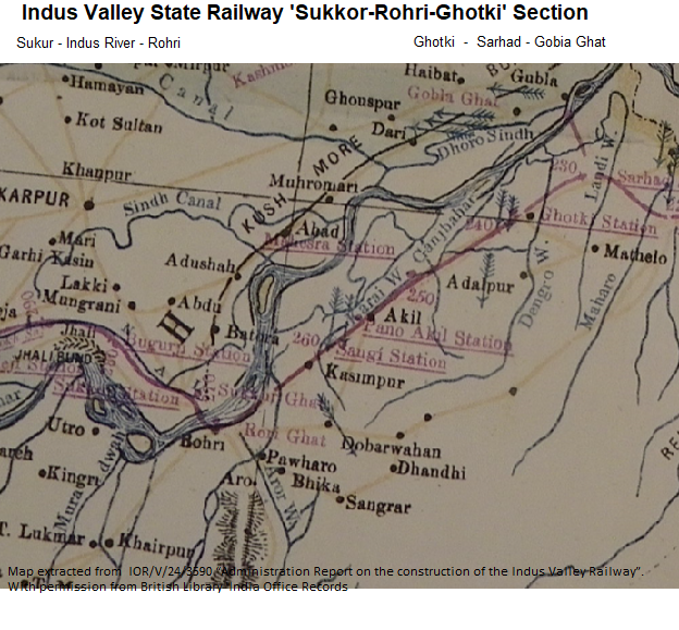
| 10:22, 21 January 2018 | Indus Valley State Railway 'Sukkor-Rohri-Ghotki' Section.png (file) |  |
649 KB | '''Indus Valley State Railway 'Sukkor-Rohri-Ghotki' Section''' Map section from British Library IOR/V/24/2359 "Administration Report on the construction of the Indus Valley Railway - Appendix" Reproduced by permission of ‘The British Library - Indi... |
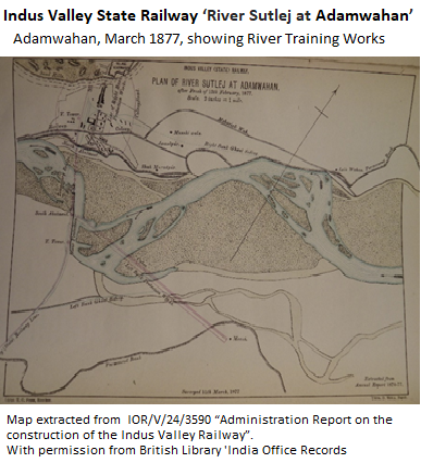
| 08:38, 21 January 2018 | Indus Valley State Railway ‘River Sutlej at Adamwahan’.png (file) |  |
212 KB | '''Indus Valley State Railway ‘River Sutlej at Adamwahan’ ''' Map section from British Library IOR/V/24/2359 "Administration Report on the construction of the Indus Valley Railway - Page 22" Reproduced by permission of ‘The British Library - In... |
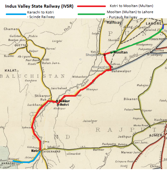
| 16:55, 20 January 2018 | Indus Valley State Railway.png (file) |  |
409 KB | '''Indus Valley State Railway''' Map taken from Imperial Gazetteer of India, v. 26, 1909, Railway Map-Section 1, p. 23 and suitably modified . To see original enhanced image [http://dsal.uchicago.edu/reference/gaz_atlas_1909/pager.html?object=29 Cl... |
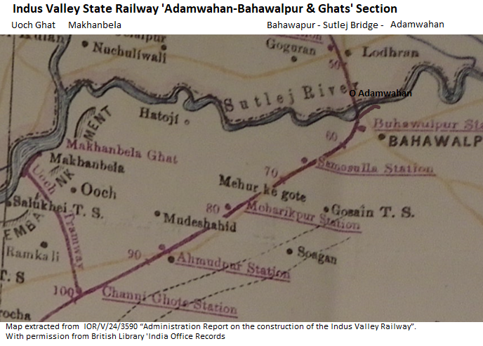
| 15:17, 20 January 2018 | Indus Valley State Railway 'Adamwahan-Bahawalpur & Ghats' Section.png (file) |  |
401 KB | '''Indus Valley State Railway 'Adamwahan-Bahawalpur & Ghats' Section''' Map section from British Library IOR/V/24/2359 "Administration Report on the construction of the Indus Valley Railway - Appendix" Reproduced by permission of ‘The British Libra... |
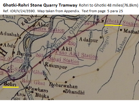
| 11:31, 19 January 2018 | Ghotki-Rohri Stone Quarry Tramway.png (file) |  |
248 KB | '''Ghotki-Rohri Stone Quarry Tramway''' Map section from British Library IOR/V/24/2359 "Administration Report on the construction of the Indus Valley Railway - Appendix" Reproduced by permission of ‘The British Library - India Office Records’.... |
| 15:26, 31 December 2017 | East Bengal Railway - Narrow Gauge System 1909.png (file) |  |
204 KB | '''East Bengal Railway - Narrow Broad Gauge System 1909''' From "Imperial Gazetteer of India, v. 26, Atlas 1909 edition, Railway Map--Sectional (2), p. 24." Extracted from [http://dsal.uchicago.edu/reference/gaz_atlas_1909/pager.html?object=30 Click... |
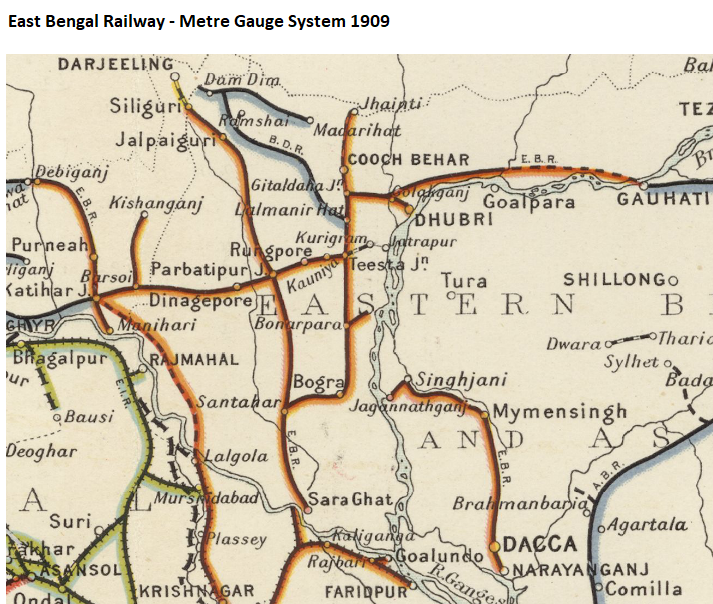
| 14:34, 31 December 2017 | East Bengal Railway - Metre Gauge System 1909.png (file) |  |
722 KB | '''East Bengal Railway - Metre Gauge System 1909''' From "Imperial Gazetteer of India, v. 26, Atlas 1909 edition, Railway Map--Sectional (2), p. 24." Extracted from [http://dsal.uchicago.edu/reference/gaz_atlas_1909/pager.html?object=30 Click here] a... |
| 14:26, 31 December 2017 | East Bengal Railway - Broad Gauge Division 1909.png (file) |  |
446 KB | '''East Bengal Railway - Broad Gauge Division 1909''' From "Imperial Gazetteer of India, v. 26, Atlas 1909 edition, Railway Map--Sectional (2), p. 24." Extracted from [http://dsal.uchicago.edu/reference/gaz_atlas_1909/pager.html?object=30 Click here]... |
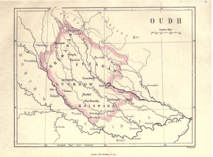
| 10:14, 18 December 2017 | Oude Province 1871.png (file) |  |
554 KB | '''Oude Province 1871 Map''' Map from 'A Text Book of Indian History' by Rev G U Pope Section §11 pdf page 24. Published by J.Gladding & Co, London, 1871 [[https://archive.org/stream/textbookofindian00popeuoft#page/n24/mode/1up Archive.org 'A Text Bo... |
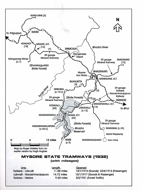
| 05:57, 4 October 2017 | Mysore State Tramways.jpg (file) |  |
90 KB | ''' Mysore State Tramways''' Map from "Industrial Railway Record 212 March 2013 The Mysore Iron & Steel Works" by Allan C Baker, page 495 ‘Map of the Mysore State Tramways’, drawn by Rodger Hateley from an earlier version by Hugh Hughes. Reproduce... |
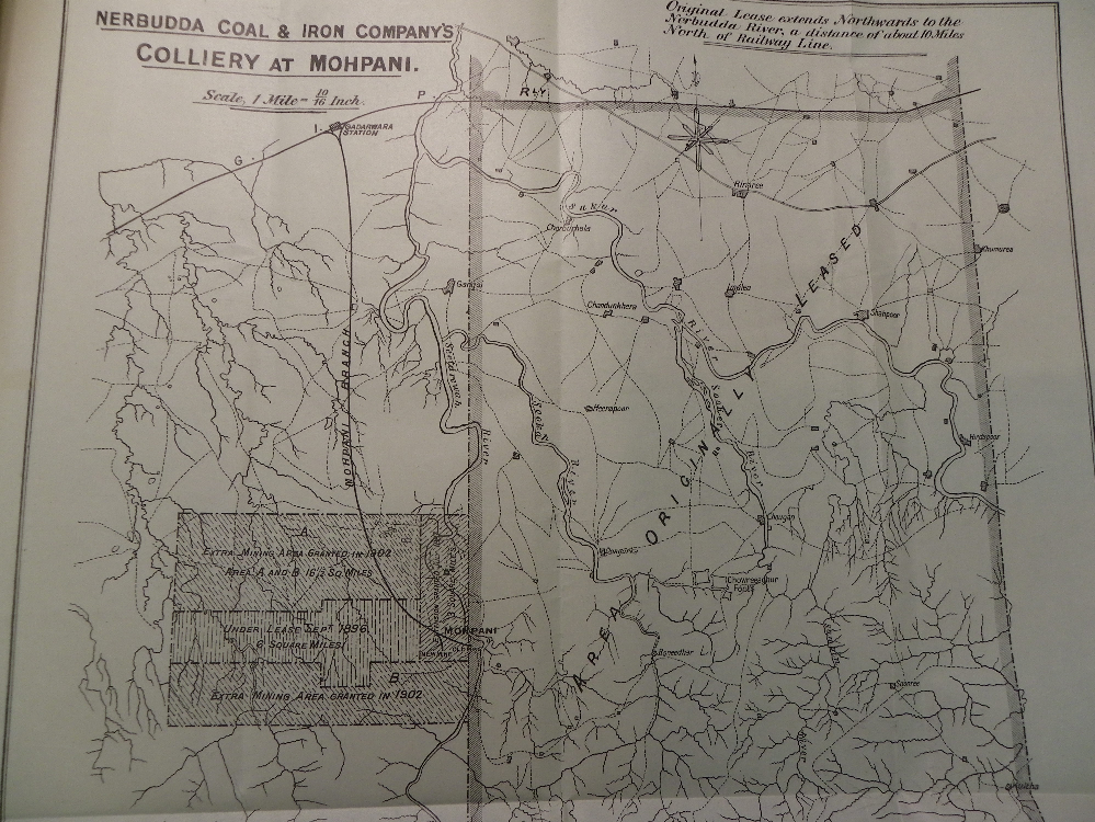
| 06:27, 27 August 2017 | Mohpani-Nerbudda Colliery Railway.png (file) |  |
1.26 MB | '''Mohpani/Nerbudda Colliery''' ‘Nerbudda Coal & Iron Company’ British Library Indian Office Records L/F/8/17/1298 “GIPR Contacts for working the Nerbudda Colliary”. Photograph of map by permission of British Library. [[Category:Ra... |
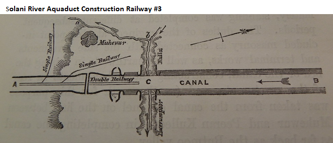
| 10:03, 15 August 2017 | Solani River Aquaduct Construction Railway -3.png (file) |  |
301 KB | Drawing extracted from “Report on the Ganges Canal Works from commencent until the opening of the canal in 1854” by Colonel Sir Proby T. Cautley, K. C. B. F. R. S.; Vol II, Chapter IX Page 419 to 428 British Library India Office Records V/27/733/10... |
| 10:00, 15 August 2017 | Solani River Aquaduct Construction Railway -2.png (file) |  |
515 KB | Drawing extracted from “Report on the Ganges Canal Works from commencent until the opening of the canal in 1854” by Colonel Sir Proby T. Cautley, K. C. B. F. R. S.; Vol II, Chapter IX Page 419 to 428 British Library India Office Records V/27/733/10... |
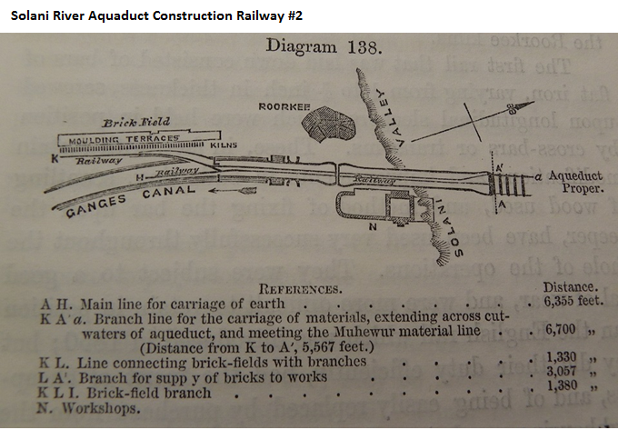
| 18:02, 14 August 2017 | Solani River Aquaduct Construction Railway -1.png (file) |  |
515 KB | Drawing extracted from “Report on the Ganges Canal Works from commencent until the opening of the canal in 1854” by Colonel Sir Proby T. Cautley, K. C. B. F. R. S.; Vol II, Chapter IX Page 419 to 428 British Library India Office Records V/27/733/10 |
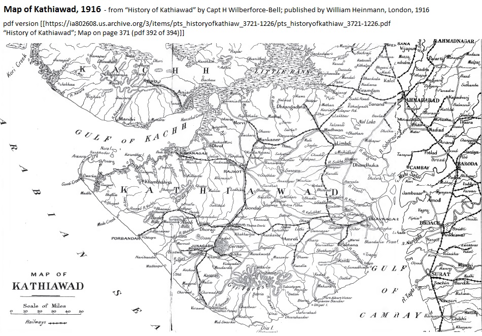
| 10:52, 18 June 2017 | Kathiawad 1916 Map.jpg (file) |  |
313 KB | The '''Kathiawad 1916 Map'''reproduced from the “History of Kathiawad” by Capt H Wilberforce-Bell; published by William Heinmann, London, 1916. Available at [https://archive.org/details/pts_historyofkathiaw_3721-1226]; pdf version [https://ia8026... |
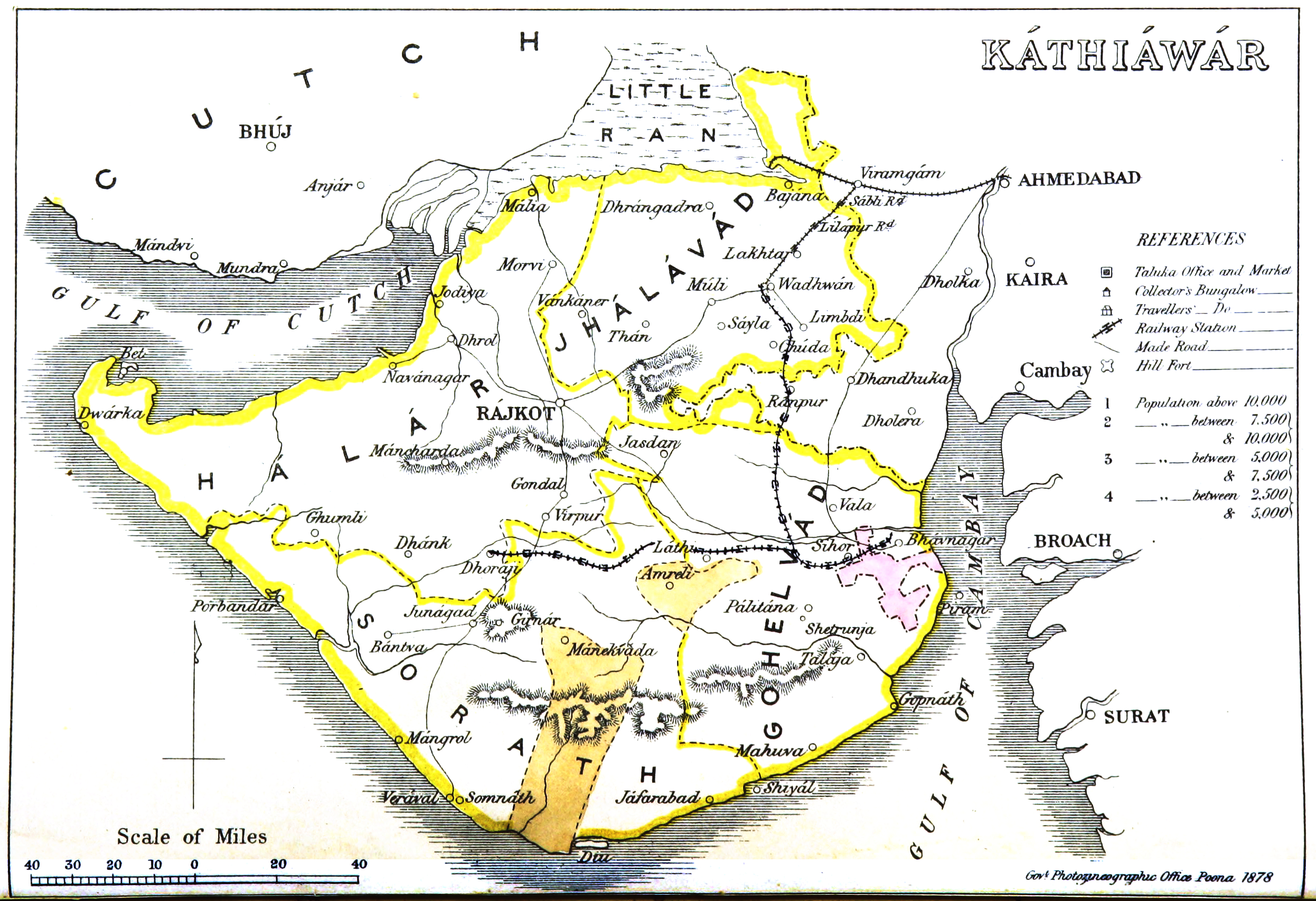
| 10:36, 18 June 2017 | Kathiawar 1878 Map.jpg (file) |  |
2.87 MB | The '''Kathiawar 1878 Map''' produced by the Government Photographic Department, Poona dated 1878. Available at [https://upload.wikimedia.org/wikipedia/commons/4/4e/Kathiawar_map.jpg Wikimedia “Kathiawar Map, 1878”] |
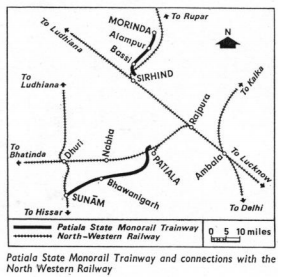
| 05:51, 18 May 2017 | Patiala State Monorail Trainways.png (file) |  |
72 KB | '''Patiala State Monorail Trainways''' <br>Map from [http://www.irfca.org/members/ddickens/PSMTArticle.pdf ‘The Railway Magazine’, February 1969, “An Indian “Might Be” by H.R.Ambler pages 72-76, reproduced by IRFCA (Indian Railways Fan Club)] |
| 09:27, 16 May 2017 | Caillet System Monorail.png (file) |  |
146 KB | '''Caillet System Monorail''' <br>Drawing of the Caillet System taken from IOR/ L/MIL/7/14846 Memorandum 9764 190 3 “British Library” with permission. Category:Railway images |
| 05:55, 15 May 2017 | Ewing Monorail System.png (file) |  |
733 KB | ''' Ewing System Monorail''' <br>Illustration from [https://www.google.com/patents/US541732 26/2/2017 ‘“Ewing System Patent 1894-95”] ]] |
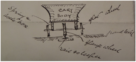
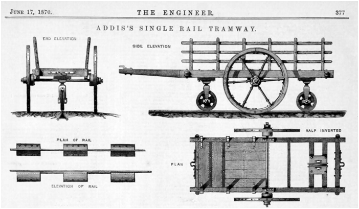
| 06:25, 12 May 2017 | Addis Monorail System.png (file) |  |
314 KB | '''Addis System Monorail''' == Summary == Illustration from [http://www.gracesguide.co.uk/images/1/13/Er18700617.pdf ‘The Engineer’ 17 Jun 1870, page 377 (‘Graces Guide’ pdf 5) ‘Addis’s Single Line Tramway’] == Licensing == {{cc-by-nc... |
| 16:41, 7 May 2017 | Jammu & Kashmir Railway Map.png (file) |  |
263 KB | '''Jammu_&_Kashmir_Railway_- showing Indian State Section''' From Imperial Gazetteer of India, v. 26, 1909, Railway Map-Section 1, p. 23. Extracted from [http://dsal.uchicago.edu/reference/gaz_atlas_1909/pager.html?object=29 Click here] and Zoomed u... |
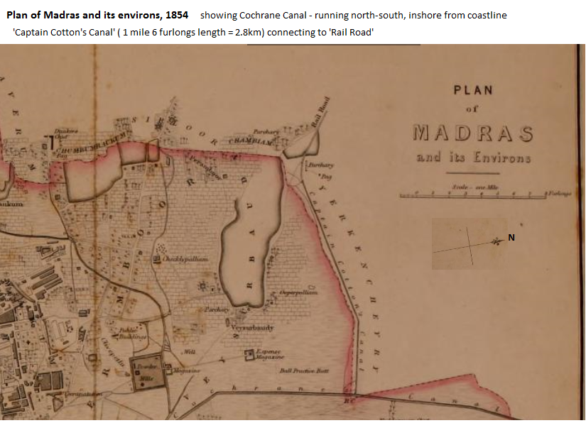
| 07:31, 23 December 2016 | Plan of Madras and its environs, 1854 v3.png (file) |  |
444 KB | '''Plan of Madras and its Environs 1854''' Part of the Map of Madras. Constables Atlas of India Cottons canal shown at the top and the line of the railroad "Constables Atlas of India", 1854, Plate 41 Cottons canal shown at the top and the line of th... |
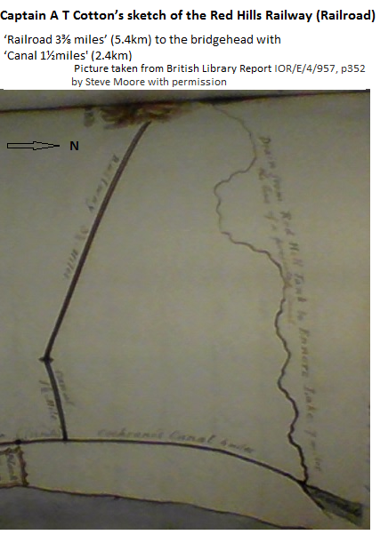
| 07:21, 23 December 2016 | Capt. A T Cottons sketch of The Redhills Railroad v5 (rotated).png (file) | .png) |
244 KB | '''Captain A T Cotton’s sketch of proposed railway and canal''' Capt. A T Cottons sketch of The Redhills Railroad to the bridgehead with "Cottons Canal" Picture taken from British Library Report IOR/E/4/957, p352 by Steve Moore and published with pe... |
| 13:19, 22 December 2016 | Villupuram-Dharmavaram Railway v2.png (file) |  |
308 KB | '''Villupuram-Dharmavaram Railway''' From Imperial Gazetteer of India, v. 26, 1909, Railway Map-Section 3, p. 25. Extracted from [http://dsal.uchicago.edu/reference/gaz_atlas_1909/pager.html?object=31 Click here] and Zoomed using navigation window... |
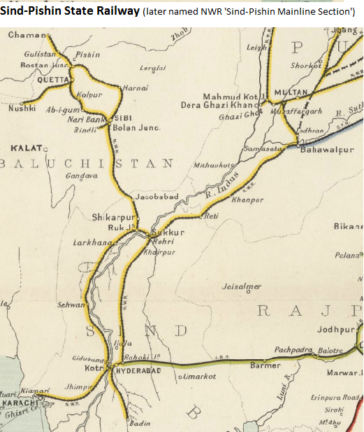
| 14:46, 20 December 2016 | Sind-Pishin State Railway 1.png (file) |  |
431 KB | == Summary == '''Sind-Pishkin State Railway''' 1909 From Imperial Gazetteer of India, v. 26, 1909, Railway Map-Section 1, p. 23. Extracted from [http://dsal.uchicago.edu/reference/gaz_atlas_1909/pager.html?object=29 Click here] and Zoomed using navi... |
| 10:53, 20 December 2016 | Sind-Pishin State Railway 3.png (file) |  |
428 KB | '''Sind-Pishkin State Railway''' From Imperial Gazetteer of India, v. 26, 1909, Railway Map-Section 1, p. 23. Extracted from [http://dsal.uchicago.edu/reference/gaz_atlas_1909/pager.html?object=29 Click here] and Zoomed using navigation window [[Cat... |
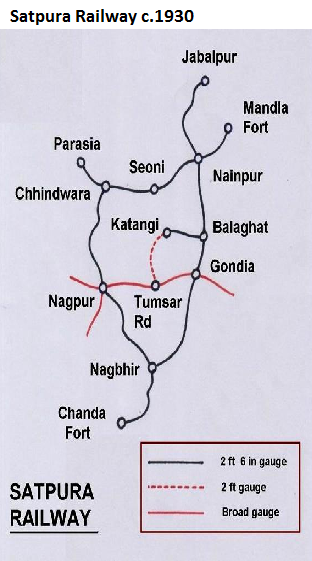
| 17:03, 12 December 2016 | Satpura Railway c.1930.png (file) |  |
190 KB | '''Satpura Railway c.1930''' From “Railways of the Raj - A Tribute to the Satpura Railway” dated 10 May 2013; uploaded from [http://railwaysofraj.blogspot.fr/2013/05/a-tribute-to-satpura-railway-part-i.html ] 12 Dec 2016. Category:Railway maps |
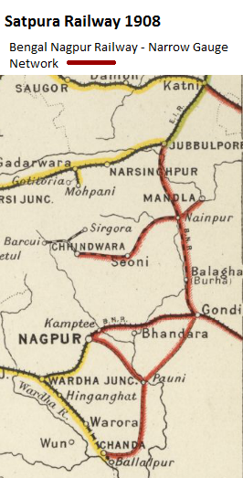
| 16:49, 12 December 2016 | Satpura Railway 1909.png (file) |  |
188 KB | '''Satpura Railway 1909''' From Imperial Gazetteer of India, v. 26, 1909, Railway Map-Section 1, p. 24. Extracted from [http://dsal.uchicago.edu/reference/gaz_atlas_1909/pager.html?object=29 Click here] and Zoomed using navigation window [[Cate... |
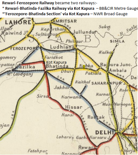
| 15:41, 7 December 2016 | Rewari-Ferozepore Railway 2.png (file) |  |
335 KB | '''Rewari-Ferozepore Railway''' From Imperial Gazetteer of India, v. 26, 1909, Railway Map-Section 3, p. 25. Extracted from [http://dsal.uchicago.edu/reference/gaz_atlas_1909/pager.html?object=31 Click here] and Zoomed using navigation window [[Cat... |
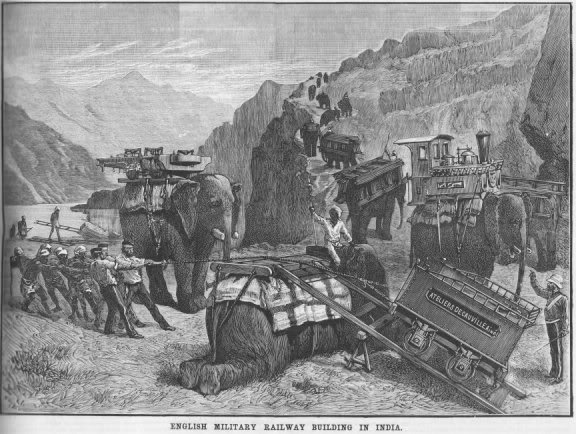
| 09:53, 5 December 2016 | Bolan Pass Railway Construction.jpg (file) |  |
69 KB | '''Bolan Pass Railway Construction - early 1880's using Elephants to transport the Decauville railway components. <ref>[http://images.google.fr/imgres?imgurl=http%3A%2F%2Fwww.andrewgrantham.co.uk%2Fimages%2Frail%2Faf-englishmilitaryrailwaybuildinginin... |
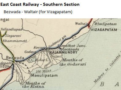
| 06:20, 3 December 2016 | East Coast Railway - Southern Section.png (file) |  |
165 KB | '''East Coast Railway - Southern Section''' From Waltair to Rajahmundry - from 1901 '''Madras Railway'''(MR later M&SMR) From Imperial Gazetteer of India, v. 26, 1909, Railway Map-Section 3, p. 25. Extracted from [http://dsal.uchicago.edu/reference... |
| 06:12, 3 December 2016 | East Coast Railway - Northern Section.png (file) |  |
242 KB | '''East Coast Railway - Northern Section''' including 'Naupada Salt Branch' and 'Puri Branch' Visianagram to Cuttack - from 1902 '''Madras Railways''' From Imperial Gazetteer of India, v. 26, 1909, Railway Map-Section 2, p. 24. Extracted from [http... |
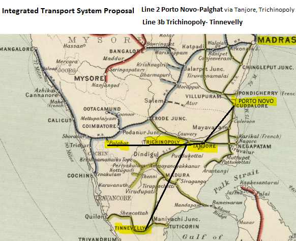
| 12:58, 28 November 2016 | Integrated Transport Proposal 1836 Line 2+3b.png (file) | 438 KB | '''Integrated Transport System Proposal 1836 - Line 2 and Line 3b''' Map extracted from Imperial Gazetteer of India, v. 26, 1909, Railway Map-Section 1, p. 24. Extracted from [http://dsal.uchicago.edu/reference/gaz_atlas_1909/pager.html?object=29 C... | |
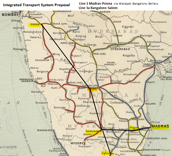
| 12:49, 28 November 2016 | Integrated Transport Proposal 1836 Line 1+3a.png (file) | 671 KB | '''Integrated Transport System Proposal 1836 - Line 1 and Line 3a''' Map extracted from Imperial Gazetteer of India, v. 26, 1909, Railway Map-Section 1, p. 24. Extracted from [http://dsal.uchicago.edu/reference/gaz_atlas_1909/pager.html?object=29 C... | |
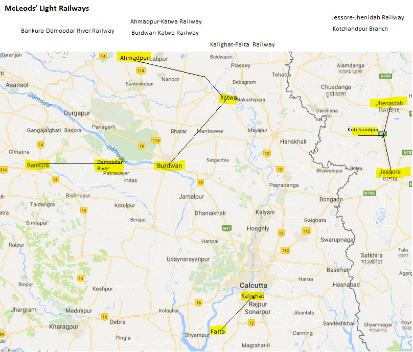
| 15:47, 24 November 2016 | Mcleod's Light Railways 5.png (file) |  |
391 KB | '''McLeod’s Light Railways''' Extractred from Google Maps with added information Category:Railway_maps |
| 06:19, 24 November 2016 | Ranaghat-Krishnangar Light Railway.png (file) |  |
116 KB | '''Ranaghat-Krishnangar Light Railway''' Category:Railway_maps |
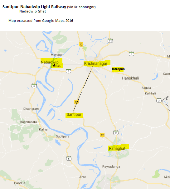
| 14:36, 23 November 2016 | Santipur-Nabadwip Light Railway (via Krishnangar).png (file) | .png) |
117 KB | '''Santipur-Nabadwip Light Railway''' From Google Maps 2016 Category:Railway_maps |
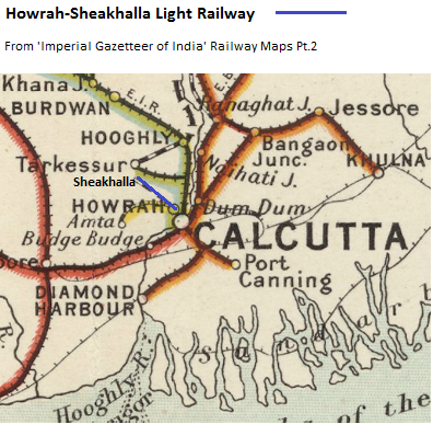
| 06:33, 15 November 2016 | Howrah-Sheakhalla Light Railway Map 1909.png (file) |  |
280 KB | |
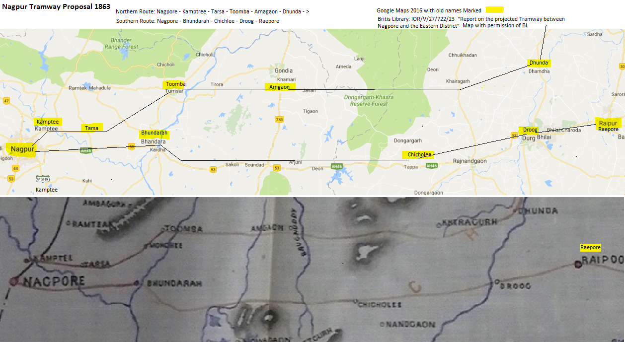
| 06:14, 2 November 2016 | Nagpur Tramway Proposal 1863.png (file) |  |
482 KB | Nagpur Tramway Proposal 1863 |
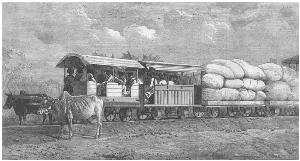
| 07:10, 22 October 2016 | Gaekwar's Dabhoi Railway Bullock Hauled Train.png (file) |  |
564 KB | '''Gaekwar's Dabhoi Railway Bullock Hauled Train 1863''' Courtesey IRFCA Indian Railways Fan Club and Wikipedia |
| 05:31, 15 October 2016 | Gaekwars Baroda State Railways Logo.png (file) | 187 KB | '''Gaekwars Baroda State Railways Logo''' From Railway Heritage Park - Dabhoi | History of Vadodara - Baroda www.historyofvadodara | |
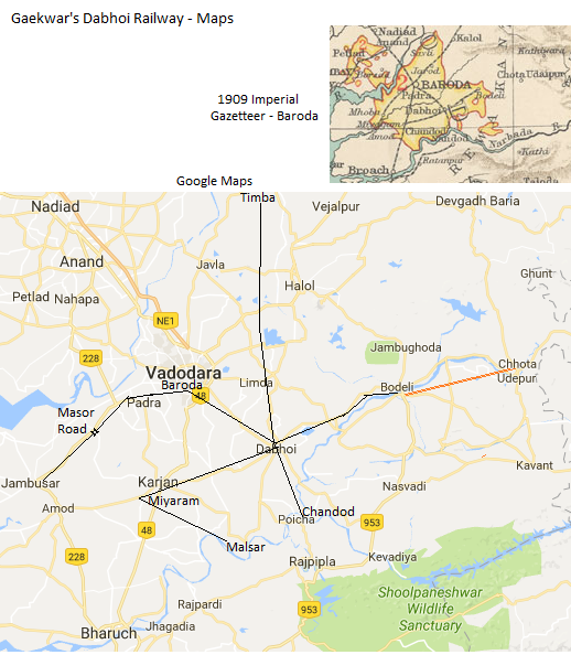
| 15:32, 13 October 2016 | Gaekwars Dabhoi Railway Maps.png (file) |  |
251 KB | '''Gaekwars Dabhoi Railway Maps''' 1909 Map extracted from - from "Imperial Gazetteer of India, 1909" Vol 7. p.64 To see original image [http://dsal.uchicago.edu/maps/gazetteer/images/gazetteer_V7_-pg64.jpg Click here] Google Maps 2016, with added... |
| 07:21, 12 October 2016 | Baroda State Map, 1909.jpg (file) |  |
265 KB | == Summary == '''Baroda State Map 1909''' From "Imperial Gazetteer of India, 1909" Category:Map images |
| 05:33, 7 October 2016 | Udaipur-Chitor Railway Railway Map 1909.png (file) |  |
348 KB | '''Udaipur-Chitor Railway''' From Imperial Gazetteer of India, v. 26, 1909, Railway Map-Section 1, p. 23. Extracted from [http://dsal.uchicago.edu/reference/gaz_atlas_1909/pager.html?object=29 Click here] and Zoomed using navigation window [[Categor... |
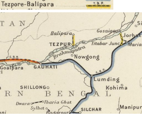
| 05:22, 7 October 2016 | Tezpore-Balipara Light Railway Map 1909.png (file) |  |
251 KB | '''Tezpore-Balipara Light Railway''' From Imperial Gazetteer of India, v. 26, 1909, Railway Map-Section 2, p. 24. Extracted from [http://dsal.uchicago.edu/reference/gaz_atlas_1909/pager.html?object=30 Click here] and Zoomed using navigation window [... |
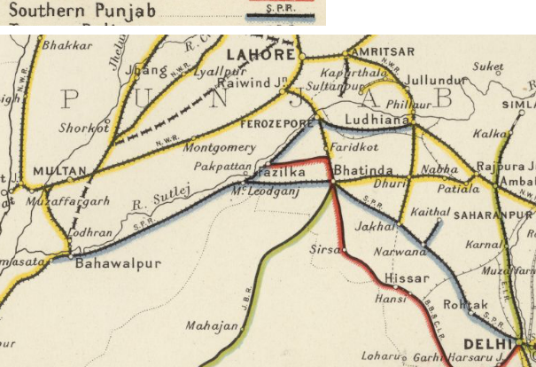
| 05:09, 7 October 2016 | Southern Punjab Railway Map 1909.png (file) |  |
419 KB | '''Southern Punjab Railway''' From Imperial Gazetteer of India, v. 26, 1909, Railway Map-Section 1, p. 23. Extracted from [http://dsal.uchicago.edu/reference/gaz_atlas_1909/pager.html?object=29 Click here] and Zoomed using navigation window [[Catego... |
| 15:47, 6 October 2016 | Southern Mahratta Railway Map 1909, south section.png (file) |  |
900 KB | '''Southern Mahratta Railway''' - south section From Imperial Gazetteer of India, v. 26, 1909, Railway Map-Section 3, p. 25. Extracted from [http://dsal.uchicago.edu/reference/gaz_atlas_1909/pager.html?object=31 Click here] and Zoomed using navigati... |
| 15:45, 6 October 2016 | Southern Mahratta Railway Map 1909, north section.png (file) |  |
924 KB | '''Southern Mahratta Railway''' - north section From Imperial Gazetteer of India, v. 26, 1909, Railway Map-Section 3, p. 25. Extracted from [http://dsal.uchicago.edu/reference/gaz_atlas_1909/pager.html?object=31 Click here] and Zoomed using navigati... |