Dagshai: Difference between revisions
Jump to navigation
Jump to search
No edit summary |
m church and cemetery |
||
| Line 16: | Line 16: | ||
==FIBIS Resources== | ==FIBIS Resources== | ||
*[http://search.fibis.org/frontis/bin/aps_browse_sources.php?mode=browse_dataset&id=1787&s_id=1004&sort=0&st=0&np=6&tn=156 Transcriptions and images of graves at Dagshai Roman Catholic Cemetery] Fibis database | *[http://search.fibis.org/frontis/bin/aps_browse_sources.php?mode=browse_dataset&id=1787&s_id=1004&sort=0&st=0&np=6&tn=156 Transcriptions and images of graves at Dagshai Roman Catholic Cemetery] Fibis database | ||
== Churches== | |||
* St Patrick's Roman Catholic Church | |||
==Cemeteries== | |||
* St Patrick's Roman Catholic Cemetery (For link to details of memorials see FIBIS Resources above) | |||
==External links== | ==External links== | ||
Revision as of 19:52, 20 March 2014
| Dagshai | |
|---|---|

| |
| Presidency: Bengal | |
| Coordinates: | 30.88°N 77.05°E |
| Altitude: | 1,734 m (5,689 ft) |
| Present Day Details | |
| Place Name: | Dagshai |
| State/Province: | Himachal Pradesh |
| Country: | India |
| Transport links | |
| Kalka-Simla Railway | |
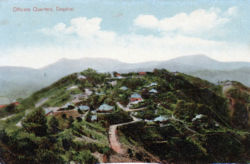
Dagshai is a hill station founded in 1847 by the East India Company after it acquired the land from the Maharaja of Patiala along with the villages of Dabbi, Bughtiala, Chunawag and Jawag. [1].
A cantonment was located there.
FIBIS Resources
Churches
- St Patrick's Roman Catholic Church
Cemeteries
- St Patrick's Roman Catholic Cemetery (For link to details of memorials see FIBIS Resources above)
External links
- Dagshai Wikipedia
- Dagshai page 118 Gazetteer of the Simla District 1904 Google Books
- St Patrick’s Roman Catholic Church, Dagshai, part of the Catholic Diocese of Shimla-Chandigarh, a volunteer news item from the Gravestone Photographic Resource. A researcher advised he was able to obtain a copy of a record from the baptismal register of this church, in respect of a relative born 1917, from the parish priest.[2]
- Churches and Cemeteries of Himachal Pradesh from Himachal Tourism has sections on Dagshai, Kasauli , and Subathu, in addition to Simla and other towns
- A piece of love falls prey to superstition by Jagmeet Y. Ghuman November 14, 2007 Hill Post. About Dagshai Cemetery
- Dagshai of yore and now by Maniki Deep Saturday 17 October 1998 tribuneindia.com
- A neglected reminder of the Raj by Romesh Dutt 6 February 1999 tribuneindia.com
- Dagshai - A Mughal time Village with British Cemeteries 31st August 2012 Sumit Raj Vashisht’s himalayanpictures.blogspot.co.uk
- The dark secret of Dagshai by Malvika K. Singh Sunday, 23 September 2012 www.tribuneindia.com "The little-known cantonment town has a cellular jail and museum..."
- Postcard: Dagshai. Married Quarters stamps-auction.com
- Photograph: Arthur Calkin in Dagshai, India 1913, with a group of soldiers outside their barracks, with their dogs and a cat. They were in the 4th Battalion, The Rifle Brigade. Family website.
- "The Forgotten Shaheeds of Dagshai" by K S Sarkaria. Contains mention of the Prison, the Gallows and the Boer Prisoner of War Camp, where there were about 290 prisoners. There is also a photograph of Dagshai taken by one of the Boer POWs, C. Lonn
References
- ↑ A neglected reminder of the Raj By Romesh Dutt
- ↑ By email dated 20 June 2013 to User:Maureene