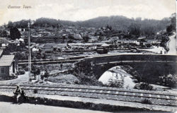
Coonoor: Difference between revisions
Jump to navigation
Jump to search
Symorsebrown (talk | contribs) Internal link, category |
Symorsebrown (talk | contribs) Add Fibis ressources |
||
| Line 15: | Line 15: | ||
*[[Nilgiri Hills]] | *[[Nilgiri Hills]] | ||
*[[List of cemeteries#N|List of Cemeteries-Nilgiri District]] | *[[List of cemeteries#N|List of Cemeteries-Nilgiri District]] | ||
==FIBIS Resources== | |||
[[:Category:Coonoor images|Coonoor images]] | |||
==External links== | ==External links== | ||
Revision as of 09:57, 15 May 2016
| Coonoor | |
|---|---|

| |
| Presidency: Madras | |
| Coordinates: | 11.35°N 76.82°E |
| Altitude: | 1,850 m (6,070 ft) |
| Present Day Details | |
| Place Name: | Coonoor |
| State/Province: | Tamil Nadu |
| Country: | India |
| Transport links | |
| Nilgiri Mountain Railway | |
Coonoor was the second largest hill station in the Madras Presidency during the British period.
Related articles
FIBIS Resources
External links
- Coonoor Town Imperial Gazetteer
- St Joseph's College, Coonor. . An advertisement from The Nilgiri Guide and Directory 1916.
- UPASI (The United Planters' Association of Southern India) is an apex body of planters of tea, coffee, rubber, pepper and cardamom in the Southern States of India viz. Tamil Nadu, Kerala and Karnataka in existence since 1893, located at Coonoor. They have records of all planters [for that area] and an extensive library going back nearly 100 years. [1]
- Article A tea industry anniversary by S. Muthiah, Madras Miscellany March 24, 2013 The Hindu. The first tea auction at Coonoor was in 1863.
References
- ↑ Vanya Orr, Coffee Planters in Nilgiris Hills India List 2012 (retrieved August 2014)