| The Families In British India Society (FIBIS) is a self-help organisation devoted to members researching their British India family history and the background against which their ancestors led their lives in India under British rule. Let FIBIS help you break down those brick walls in your research |
Gujranwala District: Difference between revisions
Jump to navigation
Jump to search
modern divisions added |
→Headquarters: sheikhupura |
||
| Line 12: | Line 12: | ||
==Headquarters== | ==Headquarters== | ||
* 1849 to 1851: Fort at [[Sheikhupura]] | |||
* [[Gujranwala]] | * [[Gujranwala]] | ||
==Neighbours== | ==Neighbours== | ||
Revision as of 12:55, 8 November 2009
| Gujranwala District | |
|---|---|

| |
| Presidency: Bengal | |
| Coordinates: | |
| Altitude: | |
| Present Day Details | |
| Place Name: | Gujranwala District, Hafizabad District, Nankana Sahib District, Sheikhupura District |
| State/Province: | Punjab |
| Country: | Pakistan |
| Transport links | |
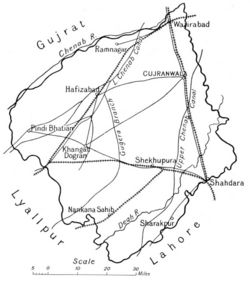
Gujranwala District was part of Lahore Division of Punjab.
Headquarters
- 1849 to 1851: Fort at Sheikhupura
- Gujranwala
Neighbours
- North-Western: Rive Chenab
- South: Lahore District
- North East: Sialkot District
Area
- 1881: 2,587 square miles
Population
- 1881: 616, 892.
History
Geography
Cities and Towns
In 1881, there were 1,146 towns and villages in the district.
- Gujranwala
- Hafizabad
- Sheikhupura
- Wazirabad
Sub-divisions
There were three tehsils:
- Gujranwala
- Hafizabad
- Wazirabad
Transportation
Rail
Road
- The Grand Trunk (G.T.) Road passes through here.
Reading
- Gazetteer of the Gujranwala District 1883-4, Lahore. Reprinted by Sang-e-Meel Publications, Lahore 2004