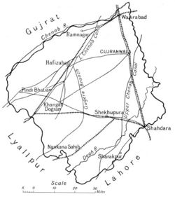
Gujranwala District
| Gujranwala District | |
|---|---|

| |
| Presidency: Bengal | |
| Coordinates: | |
| Altitude: | |
| Present Day Details | |
| Place Name: | Gujranwala District, Hafizabad District, Nankana Sahib District, Sheikhupura District |
| State/Province: | Punjab |
| Country: | Pakistan |
| Transport links | |
Gujranwala District was part of Lahore Division of Punjab Province during the British period.
Headquarters
- 1849 to 1851: Fort at Sheikhupura
- Gujranwala
Neighbours
- North-Western: River Chenab
- South: Lahore District
- North East: Sialkot District
Area
- 1881: 2,587 square miles
Population
- 1881: 616, 892.
History
Geography
Cities and Towns
In 1881, there were 1,146 towns and villages in the district.
- Gujranwala
- Hafizabad
- Sheikhupura
- Wazirabad
Sub-divisions
There were three tehsils:
- Gujranwala
- Hafizabad
- Wazirabad
Transportation
Rail
Road
- The Grand Trunk (G.T.) Road passes through here.
Reading
- Gazetteer of the Gujranwala District 1883-4, Lahore. Reprinted by Sang-e-Meel Publications, Lahore 2004
External Links
- Gujranwala District Imperial Gazetteer
- Gujranwala District Wikipedia
- Hafizabad District Wikipedia