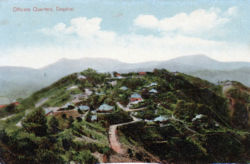
Dagshai
| Dagshai | |
|---|---|

| |
| Presidency: Bengal | |
| Coordinates: | 30.88°N 77.05°E |
| Altitude: | 1,734 m (5,689 ft) |
| Present Day Details | |
| Place Name: | Dagshai |
| State/Province: | Himachal Pradesh |
| Country: | India |
| Transport links | |
| Kalka-Simla Railway | |
Dagshai is a hill station founded in 1847 by the East India Company after it acquired the land from the Maharaja of Patiala along with the villages of Dabbi, Bughtiala, Chunawag and Jawag. [1].
A cantonment was located there.
Dagshai together with Kasauli and Subathu, were hill depots created by the British Army in the mid-19th c for the families and some of the troops to escape to in the hot weather which was so unhealthy in the plains. They are on the ridges of wooded hills about 20 kms into the Himalayas on the road between Chandigarh and Simla.[2] Kasauli is the major town in the area.
Spelling variants
Dagshai, Dugshai, Dugshaie
FIBIS Resources
Churches
- St Patrick's Roman Catholic Church
Cemeteries
- St Patrick's Roman Catholic Cemetery (For link to details of memorials see FIBIS Resources above)
External links
- Dagshai Wikipedia
- St Patrick’s Roman Catholic Church, Dagshai, part of the Catholic Diocese of Shimla-Chandigarh, a volunteer news item from the Gravestone Photographic Resource. A researcher advised he was able to obtain a copy of a record from the baptismal register of this church, in respect of a relative born 1917, from the parish priest.[3]
- Churches and Cemeteries of Himachal Pradesh, now an archived webpage, from Himachal Tourism has sections on Dagshai, Kasauli and Subathu , in addition to Simla and other towns.
- A piece of love falls prey to superstition by Jagmeet Y. Ghuman November 14, 2007 Hill Post. About Dagshai Cemetery
- Dagshai of yore and now by Maniki Deep Saturday 17 October 1998 tribuneindia.com
- A neglected reminder of the Raj by Romesh Dutt 6 February 1999 tribuneindia.com
- Dagshai - A Mughal time Village with British Cemeteries 31st August 2012 Sumit Raj Vashisht’s himalayanpictures.blogspot.co.uk
- The dark secret of Dagshai by Malvika K. Singh Sunday, 23 September 2012 www.tribuneindia.com "The little-known cantonment town has a cellular jail and museum..."
- Postcard: Dagshai. Married Quarters stamps-auction.com
- "The Forgotten Shaheeds of Dagshai" by K S Sarkaria. Contains mention of the Prison, the Gallows and the Boer Prisoner of War Camp, where there were about 290 prisoners. There is also a photograph of Dagshai taken by one of the Boer POWs, C. Lonn
Historical books online
References
- ↑ A neglected reminder of the Raj By Romesh Dutt
- ↑ Kennedy, David. Re: HURST Rootsweb India Mailing List 2 September 1998. Retrieved 9 June 2015
- ↑ By email dated 20 June 2013 to User:Maureene