Quetta
Revision as of 10:32, 6 May 2010 by Symorsebrown (talk | contribs) (Add coordinates, history, transport, external links)
| Quetta | |
|---|---|

| |
| Presidency: | |
| Coordinates: | 30.200602°N 67.034018°E |
| Altitude: | 1,900 m (6,230 ft) |
| Present Day Details | |
| Place Name: | Quetta |
| State/Province: | Baluchistan |
| Country: | Pakistan |
| Transport links | |
| North Western Railway | |
Quetta or Shal was the headquarters of the Quetta-Pishin District of Baluchistan.
Contents
History
England's March to Quetta 1842
Quetta earthquake 1935
Churches and Missions
Churches
- Mission Church (1903)
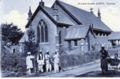
Wesleyan Church, Quetta
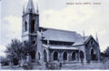
Roman Catholic Church, Quetta
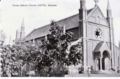
St Lukes Church, Quetta


Missions
- Church Missionary Society
- Church of England Zanana Missionary Society (zanana=women)
Further Reading
A Nursing Sister in Baluchistan by J M Morris (1932) No Preview Google Books. Experiences at a mission hospital in Quetta from 1921. Available at the British Library.
External Link
- Quetta Wikipedia
- History of Quetta Wikipedia
- Bruce Street (now Jinnah Road) before 1935 earthquake.(youtube video)
- Post office before and after earthquake (1935) (youtube video)