Difference between revisions of "Bangalore"
Jump to navigation
Jump to search
Symorsebrown (talk | contribs) (Add external link.) |
(Created image gallery) |
||
| Line 9: | Line 9: | ||
|transport= [[Chikballapur-Bangalore City Railway]]<br>[[Madras Railway]]<br>[[Mysore State Railway]]<br>[[Southern Mahratta Railway]] | |transport= [[Chikballapur-Bangalore City Railway]]<br>[[Madras Railway]]<br>[[Mysore State Railway]]<br>[[Southern Mahratta Railway]] | ||
}} | }} | ||
| − | |||
'''Bangalore''' (now '''Bengaluru''') became part of British India in 1809. It was the scene of a mutiny in 1832, which was unsuccessful. Bangalore is the capital of the modern Indian state of [http://en.wikipedia.org/wiki/Karnataka Karnataka]. | '''Bangalore''' (now '''Bengaluru''') became part of British India in 1809. It was the scene of a mutiny in 1832, which was unsuccessful. Bangalore is the capital of the modern Indian state of [http://en.wikipedia.org/wiki/Karnataka Karnataka]. | ||
| Line 24: | Line 23: | ||
*[[Bangalore Cemeteries]] | *[[Bangalore Cemeteries]] | ||
*[[Agram Cemetery, Gravestone Inscriptions 1806-1866]] | *[[Agram Cemetery, Gravestone Inscriptions 1806-1866]] | ||
| + | |||
| + | |||
| + | == Gallery== | ||
| + | <gallery> | ||
| + | File:Royal Palace, Bangalore.jpg|<center> Royal Palace, Bangalore </center> | ||
| + | File :Hosur Road Cemetery.jpg| <center> Hosur Road Cemetery, Bangalore </center> | ||
| + | </gallery> | ||
== External links == | == External links == | ||
| Line 31: | Line 37: | ||
*[http://upload.wikimedia.org/wikipedia/commons/d/d9/Bangalore1924_map.gif Bangalore map 1924] Wikipedia | *[http://upload.wikimedia.org/wikipedia/commons/d/d9/Bangalore1924_map.gif Bangalore map 1924] Wikipedia | ||
*[http://www.reocities.com/Athens/2960/index.html Ronnie Johnson's Bangalore site] - covers many topics including cemeteries, churches, streets and houses, schools and more | *[http://www.reocities.com/Athens/2960/index.html Ronnie Johnson's Bangalore site] - covers many topics including cemeteries, churches, streets and houses, schools and more | ||
| + | |||
[[Category:Locations]] | [[Category:Locations]] | ||
[[Category:Cities, towns and villages in Madras Presidency]] | [[Category:Cities, towns and villages in Madras Presidency]] | ||
Revision as of 18:17, 25 April 2011
| Bangalore | |
|---|---|

| |
| Presidency: Madras | |
| Coordinates: | 12.966667°N, 77.566667°E |
| Altitude: | 920 m (3,018 ft) |
| Present Day Details | |
| Place Name: | Bengaluru |
| State/Province: | Karnataka |
| Country: | India |
| Transport links | |
| Chikballapur-Bangalore City Railway Madras Railway Mysore State Railway Southern Mahratta Railway | |
Bangalore (now Bengaluru) became part of British India in 1809. It was the scene of a mutiny in 1832, which was unsuccessful. Bangalore is the capital of the modern Indian state of Karnataka.
History
Battle of Bangalore 1791
Bangalore Mutiny 1832
FIBIS resources
See also
Gallery
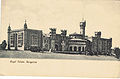
Royal Palace, Bangalore 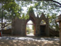
Hosur Road Cemetery, Bangalore


External links
- Churches of Bangalore Bangalorebest.com
- Bangalore Love to Know 1911
- Bangalore Wikipedia
- Bangalore map 1924 Wikipedia
- Ronnie Johnson's Bangalore site - covers many topics including cemeteries, churches, streets and houses, schools and more