Bangalore: Difference between revisions
Jump to navigation
Jump to search
add interactive map as test |
→Interactive Map: add address |
||
| Line 37: | Line 37: | ||
<googlemap version="0.9" lat="13.005896" lon="77.595062" zoom="10" controls="small"> | <googlemap version="0.9" lat="13.005896" lon="77.595062" zoom="10" controls="small"> | ||
12.95495,77.604772, Protestant cemetery | 12.95495,77.604772, Protestant cemetery, Hosur Road, Bangalore | ||
12.991793,77.612722, St John's Church | 12.991793,77.612722, St John's Church, 132 St John's Church Road, Bangalore> | ||
</googlemap> | </googlemap> | ||
Revision as of 16:44, 30 September 2011
| Bangalore | |
|---|---|

| |
| Presidency: Madras | |
| Coordinates: | 12.966667°N, 77.566667°E |
| Altitude: | 920 m (3,018 ft) |
| Present Day Details | |
| Place Name: | Bengaluru |
| State/Province: | Karnataka |
| Country: | India |
| Transport links | |
| Chikballapur-Bangalore City Railway Madras Railway Mysore State Railway Southern Mahratta Railway | |
| ' | |
|---|---|

| |
| See our interactive map of Bangalore on Google Maps | |
Bangalore (now Bengaluru) became part of British India in 1809. It was the scene of a mutiny in 1832, which was unsuccessful. Bangalore is the capital of the modern Indian state of Karnataka.
History
Battle of Bangalore 1791
Bangalore Mutiny 1832
FIBIS resources
Related articles
Gallery
-
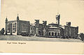
Royal Palace, Bangalore -
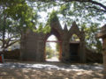
Hosur Road Cemetery, Bangalore


Interactive Map
<googlemap version="0.9" lat="13.005896" lon="77.595062" zoom="10" controls="small"> 12.95495,77.604772, Protestant cemetery, Hosur Road, Bangalore 12.991793,77.612722, St John's Church, 132 St John's Church Road, Bangalore> </googlemap>
External links
- Churches of Bangalore Bangalorebest.com
- Bangalore Love to Know 1911
- Bangalore Wikipedia
- Bangalore map 1924 Wikipedia
- Ronnie Johnson's Bangalore site - covers many topics including cemeteries, churches, streets and houses, schools and more