Sialkot District: Difference between revisions
Jump to navigation
Jump to search
m →Transportation: fix link |
info box, wikify |
||
| Line 1: | Line 1: | ||
{{Locations_Infobox | |||
|presidency= [[Bengal (Presidency)|Bengal]] | |||
|image=Sialkot_district.jpg | |||
|coordinates= | |||
|altitude= | |||
|presentname= [http://en.wikipedia.org/wiki/Sialkot_District Sialkot District] | |||
|stateprovince= [[Punjab]] | |||
|country= [[Pakistan]] | |||
}} | |||
'''Sialkot District''' was part of [[Punjab]] near Jammu and Kashmir State. It was included in [[Lahore Division]]. | '''Sialkot District''' was part of [[Punjab]] near Jammu and Kashmir State. It was included in [[Lahore Division]]. | ||
| Line 26: | Line 36: | ||
==Cities and Towns== | ==Cities and Towns== | ||
* Pasrur | * [[Pasrur]] | ||
* Sialkot | * Sialkot | ||
* Zafarwal | * [[Zafarwal]] | ||
| Line 45: | Line 55: | ||
* Section beyond Sialkot to Jammu Tawi | * Section beyond Sialkot to Jammu Tawi | ||
* Sialkot-Narowal Railway | * Sialkot-Narowal Railway | ||
==Reading== | ==Reading== | ||
Revision as of 09:07, 4 November 2009
| Sialkot District | |
|---|---|

| |
| Presidency: Bengal | |
| Coordinates: | |
| Altitude: | |
| Present Day Details | |
| Place Name: | Sialkot District |
| State/Province: | Punjab |
| Country: | Pakistan |
| Transport links | |
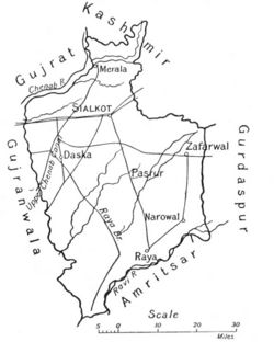
Sialkot District was part of Punjab near Jammu and Kashmir State. It was included in Lahore Division.
Headquarters
Neighbours
- North: Gujrat District and Jammu State
- South: Amritsar District
- East: Gurdaspur District.
- West: Sheikhupura District and Gujranwala District
History
In 1858, the district was divided into four tehsils: Sialkot, Zafrwal, Pasrur and Daska. In 1881, it was divided into a further tehsil of Daska. After 1912, parts of Daska and Pasrur Tehsils were given to Gujranwala District while parts of Raya Tehsil went to Sheikhupura District. By 1920, it had the following 4 tehsils: Daska, Pasrur, Sialkot and Zafarwal.
Area
- According to the 1913-14 settlement, its area was 1,962 square miles.
Population
The district's population in 1911 was 979,553.
Cities and Towns
Tehsils
- Daska
- Pasrur
- Raya
- Sialkot
- Zafarwal
Transportation
Rail
North Western Railway 5 feet 6 inches gauge system within the district. The lines were:
- Branch line from Wazirabad to Sialkot to the frontier of the Jammu State.
- Section beyond Sialkot to Jammu Tawi
- Sialkot-Narowal Railway
Reading
- Punjab District Gazetteers volumeXXIII-A Sialkot 1920, Lahore, 1921. Reprinted as Gazetter of the Sialkot District 1920, Sang-e-Meel Publications, Lahore, 2005.