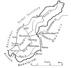
Hazara District
| Hazara District | |
|---|---|

| |
| Presidency: Bengal | |
| Coordinates: | |
| Altitude: | |
| Present Day Details | |
| Place Name: | Abbottabad District, Batagram District, Haripur District, Kohistan District, Manshera District |
| State/Province: | North West Frontier Province (NWFP) |
| Country: | Pakistan |
| Transport links | |
Hazara was a historic region, first in Punjab and later when it was transferred to the North West Frontier Province, on the latter's creation in 1901. It then became one of its five districts.
This region consists of the present day districts of Abbottabad, Batagram, Haripur, Kohistan and Manshera. It also includes the tribal area of Black Mountain (Kala Dhaka) (within Manshera district) and the Galis (within Abbottabad district).
Cities,Towns and Hill Stations
History
Battle of Hazra Jun 1888
Battle of Hazra Oct 1888
Battle of Hazra 1891
Black Mountain Expedition 1888
Black Mountain Expedition 1891
Spelling Variants
Modern name: Hazara
Variants: Hazra
External Links
- Hazara, Pakistan Wikipedia
- Abbottabad District Wikipedia
- Batagram District Wikipedia
- Haripur District Wikipedia
- Kohistan District Wikipedia
- Manshera District Wikipedia
Historical Books online
- Hazara District Imperial Gazetteer of India 1908
- Gazetteer Of The Hazara District 1907. A volume in the series N W F Province Gazetteers. Pdf download, Digital Library of India.
- A Handbook to the North-West Frontier including Jhelum Rawalpindi and Hazara Districts by Cyril James Davey 1942. Pdf download Pahar-Mountains of Central Asia Digital Dataset.