Simla
| Simla | |
|---|---|

| |
| Presidency: Bengal | |
| Coordinates: | 31.137603°N 77.128143°E |
| Altitude: | 2,900 m (9,514 ft) |
| Present Day Details | |
| Place Name: | Shimla |
| State/Province: | Himachal Pradesh |
| Country: | India |
| Transport links | |
| Kalka-Simla Railway | |
| FibiWiki Maps | |
|---|---|
| See our interactive map of this location showing places of interest during the British period | |
| Simla |
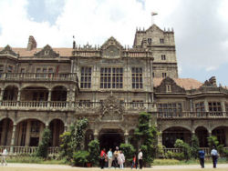
Simla was the headquarters of Simla District in the Delhi Division of Punjab Province during the British period. It was the hill station linked with Delhi and the summer retreat of the Viceroy from 1864. In the centre of Simla is the large open space known as The Ridge. The colonial-era architecture in the town is notable for its mock Tudor style.
The current name is Shimla.
Railway
The narrow gauge Kalka-Simla Railway is still operational, having opened in 1903.
Churches
- Christ Church (Anglican, built 1844-1846).
- St Michael and St Joseph's Cathedral (Roman Catholic, built 1886). Photograph (flickr.com)
- St Andrew's Church (Church of Scotland, now a library).
- St Thomas's Church (Church Missionary Society).
- All Saints Chapel.
- St Crispin's, Mashobra.
Cemeteries
- Oakover Cemetery (in use 1829-1841).
- Cart Road Cemetery (consecrated 1840).
- Kanlog Cemetery (in use 1850-1920s) (See individual fibiwiki article)
- Sanjauli Cemetery (opened 1921)
- St Bede's Cemetery (private burial ground for nuns of Convent of Jesus and Mary, also some Loreto religious)
Cemeteries from Simla, Past and Present by Edward J Buck 1904 Archive.org.
Cemeteries in Simla Brief historical background to the individual cemeteries from blog of Sumit Raj Vashit.
Schools
- Bishop Cotton School dates from 1859 and was modelled on the typical British boarding Public School of the Victorian period..
- Schools in the Simla District c 1904, page 113 Gazetteer of the Simla District 1904 Google Books
- Rare books at St Bede’s archives The Times of India. St Bede’s, a school for girls, was established in 1904.
FIBIS resources
Related articles
External links
- Simla Love to Know 1911
- Simla Town Imperial Gazetteer of India
- Shimla, Wikipedia.
- "Home from Home: The Victorians in Simla" from The Victorian Web
- Christ Church Simla is one of a number of links relating to Simla in Victorian and Edwardian Architecture in British India from The Victorian Web
- "Infusing life into British era graveyards in Himachal" WorldLatestNews.com
- New buildings in Simla 1881-1888 from Henry Irwin Architect in India 1841 – 1922
- Shimla-Heritage includes some old photographs of the town.
- History of the Viceregal Lodge iias.org
- Surrey in Tibet [Simla] by William Dalrymple 1997. travelintelligence.com. Also an episode in the 1997 TV documentary series Stones of the Raj
- Deodar Tales: Shimla: Heritage Homes OutlookIndia.com 19 April 2010
- Shimla, India: The queen of hills telegraph.co.uk 16 October 2011
- Shimla-Chandigarh Diocese, Catholic Church
- An article about Dorothy Sanders, who was deaf and spent her childhood in India. It briefly mentions she attended a "hearing school" in Simla, (probably circa 1900/1910). The Silent Worker, Volume 32, No.6, March 1920 from the Gallaudet University Archives, WRLC Libraries Digital and Special Collections
- Colonial Boy by John Alton Price, born 1923 in Simla where he spent his childhood, attending Bishop Cotton School from age 9. From his family website.
- "An officer in Simla" Part 1 Part 2 An album of photographs and other items from Ian Hamilton's time in Simla, India 1885-1887 from "The Serving Soldier" collection, King’s College London
- The dakiya and the dak ghar by Sarita Brara September 20, 2012 The Hindu. The Shimla General Post Office opened in 1883.
Historical books on-line
- 1909 Map of Simla Imperial Gazetteer of India, Volume 26, Atlas 1909 edition, page 61.
- 1931 Map of Simla Imperial Gazetteer of India, Volume 26, Atlas 1931 edition, page 63.
- Gazetteer of the Simla District 1904 being Punjab District Gazetteers Volume VIII-A (reprint). Preview Google Books
- Simla, Past and Present by Edward J Buck 1904 Archive.org. It includes a chapter on Cemeteries
- Kennedy, Dane. The Magic Mountains: Hill Stations and the British Raj (full text, searchable). Berkeley: University of California Press, 1996. ISBN 0520201884. ISBN 978-0520201880
- Thackers Indian Directory 1908 is available to read online on Digital Library of India website. The Mofussil Directory entry for Simla is pages 529-539, computer pages 792-802. Includes List of Residents, page 532, computer page 795. For additional directories available online, refer Directories online.