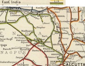
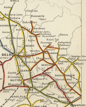
East Indian Railway - Lines owned and worked
East Indian Railway - Lines owned and worked
- a sub-section of the East Indian Railway(EIR) page


East Indian Railway(EIR) owned and operated an extensive network of railways of broad gauge(BG);, in 1905 the route mileage was 1962 miles(3157km) and by 1918 was 2775 miles( 4465km)
The EIR also managed, worked and maintained a number of lines on behalf of other parties.
The listings below are generally based on the “Administration Report on Railways 1918” [1] with page numbers (and pdf pages) noted at the end of each entry.
BG Lines - owned and worked by EIR
1918 Total - 2464 miles(3965km). Page 53 (pdf 62)
- Howrah-Delhi EIR Main Line; first section Howrah to Hooghly, 24 miles(38km,) opened 1854; via Khana Junction-Bhagalpur-Jamalpur-Luckeesera-Mogul Sarai to Allahabad, 1865; reaching Delhi on 1 Jan 1867. 1021 miles(1643km). Page 53 (pdf 62)
- First Chord EIR Line ; Khana Junction-Sitarampur, opened in stages from 1855-63; reaching Luckeeserai 1871. 183 miles(294km. Page 53 (pdf 62). Initially called the Chord Line but then re-designated as the Main Line.
- Sahibganj Loop EIR Line; Khana Junction-Bhagalpur-Jamalpur-Luckeeserai section of the Main Line 250 miles(402km) became secondary with the opening of the First Chord, reducing Howrah-Delhi to 943 miles (1517km). Page 53 (pdf 62)
- Bausi Branch Railway, a branch railway from Bhagalpur to Mandar Hill; under construction 1907 for EIR as a branch of the Sahibganj Loop EIR Line; dismantled in 1917-18 for reasons unknown.
- Grand Chord EIR Line; Sitarampur-Gaya-Mogul Sarai, first section to Barakar , 1865; Gaya 1906; Mogul Sarai 1909. 278 miles(447km). Page 54 (pdf 63)
- Howrah-Burdwan Chord Line ; 6 miles from Howrah to Saktighar, 1917; 45 miles(72km). Page 54 (pdf 63)
Branches from the Howrah-Delhi EIR Main Line
Alphabetical order with page and pdf references from the “1918 Report on Railways” ” [1]
- Agra Branch Line ; Tundla to Jumna Bridge, 1862; Jumna Bridge to Agra City, 1907; total 15 miles(24km). Page 55 (pdf64)
- Allahabad Fort Branch Line ; Allahabad Fort, 1859; 2.3 miles(3.7km), Page 55 (pdf64); extension to Daraganj sanctioned 1914, 1.9 miles(3km), Page 56(pdf65)
- Bandel-Barharwa Branch Line ; Bandel to Barharwa, 1911-13; 166 miles(267km). Page 54 (pdf 63)
- Benares Chord Line ; to Bechupur, connecting to the Oudh and Rohilkhand Railway, 1910; 1.2 miles(1.9km). Page 54 (pdf 63)
- Bhadreswar Branch Line ; Bhadreswar to River Bank, 1882; 2.6 miles(4.2km). Page 54 (pdf 63)
- Cawnpore City Branch Line ; Cawnpore, 1879; 0.9 miles(1.4km). Page 55 (pdf64)
- Deoghar Branch Line ; Jasidih to Baidyanathdham, opened 1882 as the metre gauge (MG) MG Deoghur Railway, originally owned and worked by Burn & Co Ltd until merged in EIR, 1911; converted to BG 1913; 4.1 miles(6.6km). Page 54 (pdf 63)
- Digha Ghat Branch ; Bankipore to Digha Ghat, 1885; 5.5 miles(8.8km). Page 54 (pdf 63)
- Giridih Branch Line ; Madhupar to Giridih, 1871; 27 miles(43km). Page 54 (pdf 63)
- Hathras Branch Line ; Hathras Junction to Hathras Kilah, 1898; 5.6 miles(9km). Page 55 (pdf64)
- Ikrah Branch Line ; Ikrah to Barabani, 1894; Barabani to Sitarampur; total 15 miles(24km). Page 54 (pdf 63) **Jubbulpore Branch Line; Naini to Jubbulpore; 1867; 224 miles(360km). Page 54 (pdf 63)
- Mokameh Ghat Branch Line ; Tal Junction to Mokameh, 1883; 3miles(4.8km). Page 54 (pdf 63)
- Naihati Branch Line ; Bandel to Naihati, 1887; 4.5 miles(7.2km]. Page 54 (pdf 63)
- Ondal-Sainthia Chord Line ; Ondal to Sainthia, 1906; 43 miles(69km). Page 54 (pdf 63)
- Ondal Loop Line ; Ondal -Baboissola section opened 1864, constructed by the Tarkessur Railway Company and worked by EIR, incorporated into EIR 1915 as part of the ‘Ondal Loop Line’ ; Baboissola to Toposi, 1863; Toposi via Ikrah to Rupnarainpur , 1894-5; total 32 miles(51km). Page 54 (pdf 63)
- Patna Ghat Branch; Patna to Patna Ghat, 1862; 0.9 miles(1.4km). Page 54 (pdf 63)
- Patna-Gaya Branch Line ; Bankipore to Gaya(Gya) opened 1879; constructed and worked by State and named Patna & Gaya State Railway; worked by EIR from 1883 and transferred to EIR 1892; 58 miles(93km). Page 54 (pdf 63)
- Salanpur Branch Line ; Salanpur to Shamdi, 1894-7; 5.5 miles(8.8km). Page 54 (pdf 63)
- Shikohabad-Farukhabad Branch Line ; Shikohabad to Farukhabad, 1905-6; 66 miles(106km). Page 55 (pdf64)
- Tari Ghat Branch Line; Dildarnager to Tari Ghat, opened 1880 as the Dildarnagar-Ghazipur State Railway; worked by EIR; transferred to EIR 1892 becoming the EIR ‘Tari Ghat Branch Line’; 12 miles(19km). Page 54 (pdf 63)
- Tarkessur Branch Line; Sheoraphuli-Tarkessur section opened, 1885, constructed by the Tarkessur Railway Company and worked by EIR, incorporated into EIR 1915 becoming the ‘Tarkessur Branch Line’; 22 miles(35km). Page 54 (pdf 63)
- Toposi-Barabani Chord ; Toposi to Barabani, 1908 and 1915; total 6.5 miles(10.4km). Page 54 (pdf 63)
Branches from the First Chord EIR Line
Alphabetical order with page and pdf references from the “1918 Report on Railways” ” [1]
- Azimganj Branch Line; opened in 1863 as the Nalhati-Azimganj Railway, a 4ft(1222mm) unique rail gauge line from Nalhati to Azimganj, constructed and worked by the Indian Branch Railway. Lline taken over by the Government 1872 and re-named Nalhati State Railway; converted to BG in 1892 and becoming the EIR ‘Azimganj Branch Line’ ; 27 miles(43km). Page 55 (pdf64)
- Mirza Chowki Branch Line; Mirza Chowki to river side, 1909, 0.2 miles(0.3km). Page 55 (pdf64)
- Monghyr Branch Line; Jamalpur Junction to Monghyr, 1862; 5.7 miles(9.1km)
- Rajmehal Branch Line; Tinpahar Junction to Rajmehal, 1860; 7 miles(11km). Page 55 (pdf64)
- Sakrigali Branch Line; Sakriali to River Ganges, 1894, 1.3 miles(2.0km). Page 55 (pdf64)
- Sultangunge Ghat Branch Line; Sultangunge Junction to Sultangunge Ghat, 1895 1.2 miles(1.9km). Page 55 (pdf64)
Branches from the Grand Chord EIR Line
Alphabetical order with page and pdf references from the “1918 Report on Railways” ” [1]
- Barun-Daltonganj Branch Line; Sone River East Bank, Barun to Daltonganj, 1902; 78 miles(125km). Page 55 (pdf64)
- Chanch Branch Line ; Chanch to Grand Chord Line, 1893-6; 3.9 miles(6.2km). Page 55 (pdf64)
- Damudu Branch Line; Kasunda to Pathardihi, 1895-6; 9.8 miles(15.7km). Page 55 (pdf64) See separate page 'Jharia Coalfield Railways'
- Jamuniatand Link Line; Khanoodih to Bokharo Colliery Railway joint line, 1916; 2 miles(3.2km)
- Jharia Branch Line; Dhanbaid to Jharia, 1903; 3.8 miles(6km). Page 55 (pdf64) See separate page 'Jharia Coalfield Railways'
- Kasunda-Tetulmari Link Line; Kasunda to Tetulmari, 1906-7; 3.2 miles(5.1km). Page 55(pdf64)
- Katras Branch Line ; Dhanbaid to Katrasgarh, 1894; 9.1 miles(14.6km). Page 55 (pdf64) See separate page 'Jharia Coalfield Railways'
- Katras-Khanoodih Extension Line; Katrasgarh to Khanoodih, 1903; 7.2 miles(11.5km). Page 55 (pdf64)
- Katras-Mulkera Cross Connection Line; Northern half of connection, 1903, 0.7 miles(1.1km). Page 55 (pdf64)
BG Lines under Construction or Sanctioned for Construction in 1918
Alphabetical order with page and pdf references from the “1918 Report on Railways” ” [1]
- Dhanbad-Katrasgarh Line; Dhanbad to Katrasgarh and beyond, sanctioned 1918; 2.4 miles(3.8km). Page 56 (pdf65)
- Toposi-Baraboni Chord Line; Toposi to Baraboni, sanctioned 1913; 3.7 miles(5.9km). Page 56 (pdf65)
BG Lines absorbed into EIR
Alphabetical order with page and pdf references from the “1918 Report on Railways” ” [1]
- Barharwa-Azimganj-Katwa Railway, opened c.1914 as a Branch/Link line from Katwa on the Hooghly-Katwa Railway to Barharwa on the Sahibganj Loop. This 110 Mile (170km) track was worked by EIR.
- Central Indian Coalfields Railway, opened 1927. GoI owned; part worked by Bengal Nagpur Railway(BNR); later amagamated with EIR.
- Delhi-Umballa-Kalka Railway, formed 1889 as private company, Delhi to [[Kalka],] line opened 1891, 162 miles(259km), worked and maintained by EIR. Page 60 (pdf68). Merged into EIR, 1925
- Deoghur Railway ; Jasidih to Baidyanathdham, 1882, a short branch line linking important pilgrimage centre to the EIR main line; metre gauge(MG) constructed and worked by Burn & Co Ltd; merged into EIR, 1911 becoming the ‘Deoghur Branch Line’ of the Howrah-Delhi EIR Main Line. 4.1 miles(6.6km). Page 54 (pdf 63)
- Dildarnagar-Ghazipur State Railway, opened 1880 as a provincial state railway, worked by EIR and later absorbed into the EIR network becoming the Tari Ghat Branch Line of the Howrah-Delhi EIR Main Line ; Dildarnager to Tari Ghat, 1880; 12 miles(19km. Page 54 (pdf 63)
- Hooghly-Katwa Railway, opened in 1913 as a Branch/Link line from Bandel on the Hooghly- Burdwan(Bardhaman) section of the Howrah-Delhi EIR Main Line. The line linked to Katwawhere it joined to the Barharwa-Azimganj-Katwa Railway leading to Barharwa on the Sahibganj Loop. These lines formed part of the EIR network and all were worked by EIR.
- Jind-Panipat Railway, opened 1916 from Jind City , with a connection to the Southern Punjab Railway, to Panipat, worked and maintained by EIR. Total 40.66 miles(65km) comprising 25.90 miles within Jind territory and 14.76 miles in British section. Pages 60-62 (pdf 70-71)
- Sheoraphuli-Tarakeshwar Railway, owned by the Tarkessur Railway Company ; Sheoraphuli to Tarkessur, opened 1884-85. Worked by EIR and merged into EIR 1915 becoming the ‘Tarkessur Branch Line’ of the Howrah-Delhi EIR Main Line. 22 miles(35km). Page 54 (pdf 63)
- Nalhati-Azimganj Railway, opened in 1863 as a 4ft(1222mm) unique rail gauge, constructed and worked by the Indian Branch Railway. The line was taken over by the Government in 1872, and renamed the Nalhati State Railway; converted to BG in 1892 and becoming the ‘Azimganj Branch Line’ of the First Chord EIR Line ; 27 miles(43km). Page 54 (pdf 63)
- Ondal-Baboissola Railway, owned by the Tarkessur Railway Company ; Ondal to Baboissola, opened 1864, 2 miles(3.2km). Worked by EIR and merged into EIR 1915 becoming part of the ’Ondal Loop Line’ of the Howrah-Delhi EIR Main Line giving total 32 miles(51km). Page 54 (pdf 63)
- Oudh and Rohilkhand Railway(O&RR), formed from Indian Branch Railway(IBR); nationalised, 1889; merged into EIR, 1925.
- South Bihar Railway, formed 1895 as private company, Luckeeserai to Gaya, 79 miles(127km) opened 1899, leased to the State to be worked as part of the EIR network. The railway was taken over by the Government of India(GoI) in 1906.
- Thanesar-Kaithal Railway, a branch line of the Delhi-Umballa-Kalka Railway, opened 1909-10, 30 miles(48km) branch from Kurukshetra to Kathal, worked and maintained by EIR. Page 60 (pdf68).
BG Lines worked by EIR at some time
- Jind-Panipat Railway, opened 1916-17. Originally worked by EIR; later by North Western Railway(NWR)
- Calcutta Port Commissioners' Railway, opened 1892 and connected to EIR in 1924
BG Lines – EIR network expansion lines
- Calcutta Chord Railway, opened 1931-32. EIR link from Dum Dum to Dankuni over Willindon Bridge