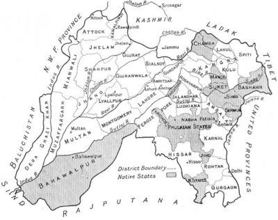
Punjab
Punjab was a British province between 1849 and 1947 that was part of the Bengal Presidency. The Punjab region covers the area of the two modern states of the same name (one on each side of the India-Pakistan border) as well as the Indian state of Haryana. At one time it also included the North West Frontier Province (until 1901) and Delhi.

History
The entire province became part of British India in 1849 after the 2nd Sikh War.
In 1901, Lord Curzon, authorised the creation of a new province out of Punjab. The North West Frontier Province was formed with 5 districts: Bannu, Dera Ismail Khan, Hazara, Kohat and Peshawar, of the old province.
Delhi was separated to form part of the new capital.
The remaining parts of Punjab was partitioned between India and Pakistan in 1947.
Government
- 1897-1920: Council of the Lieutenant Governor of the Punjab.
- 1921-1936: Punjab Legislative Council
- 1937-1947: Punjab Legislative Assembly
Legislators
Capital
Cities and Towns
In India
In Pakistan
- Attock (Cambellpur City)
- Attock Khurd
- Bhera
- Chilianwala
- Chiniot
- Dera Ghazi Khan
- Fort Munro
- Gujrat (also spelt Gujerat)
- Gujranwala
- Hasanabdal
- Jhang
- Jhelum
- Kasur
- Khewra
- Khushab
- Lahore
- Lyallpur (now Faisalabad)
- Montgomery (now Sahiwal)
- Multan
- Murree
- Muzaffargarh
- Nankana Sahib
- Pakpattan
- Rawalpindi
- Pind Dadan Khan
- Sakesar
- Shahdheri (now known as Taxila)
- Sialkot
Princely States
India
Pakistan
Divisions
The province was divided into 10 divisions (1870):
- Amritsar
- Delhi
- Derajat
- Hissar
- Jalunder
- Lahore
- Multan
- Peshawar
- Rawalpindi
- Umballa
Districts and Other Areas
Not all districts existed at the same time. This list is an attempt to list all districts that existed at one time or another under British rule.
In India
In Pakistan
- Attock District
- Chenab Colony
- Dera Ghazi Khan District
- Gujranwala District
- Jhang District
- Jhelum District
- Lahore District
- Lyallpur District
- Mianwali District
- Montgomery District (now Sahiwal District)
- Multan District
- Muzaffargarh District
- Rawalpindi District
- Shahpur District
- Sheikhupura District
- Sialkot District
NWFP
These 5 districts were part of Punjab until 1901 when they were separated to form the new province.
External Links
Wikipedia:
Historical online books:
- "Life in the Punjab" Calcutta Review Volume 26, January-June 1856 (Google Books)