User:PEA-2292/My sandbox
Kathiawar Peninsula Railway and Tramway Systems
Kathiawar is a peninsula and today forms part of the Indian State of Gujarat. The peninsula covers an area of 23,345 sq. miles (60,720 sq. Km) and in 1901 had a population of 2,645,805.[1]. Most of the area was under the jurisdiction of the Government of India, and also Portugal had the island colony of Diu on the peninsular which covered 20 sq. miles (51.8sq. Km) with a population of 14,614 [2].
Kathiawar in the late 1800’s was governed by 193 small Princely States, ruled by local potentates who acknowledged British control in return for local sovereignty. These States comprised the ‘Kathiawar Agency’. The rest of the peninsula, chiefly in the east along the Gulf of Cambay, were districts ruled directly by the British as part of British India's Bombay Presidency, which included part of the peninsula [3].
The ‘Kathiawar Agency’ was a political unit formed in 1822 with headquarters at Rajkot, the town where the British Political Agent used to reside. He reported to the Political Department office at Bombay [4]. The area was divided the area into four regions these being Halar, Jhalavad, Sorath and Gohelvad [1].
In 1872, the Bombay, Baroda and Central India Railway(BB&CIR) railway extension from Virangam reached Wadhwan[5]. This started a period of growth in metre gauge railways financed and operated by the Native States. The problem was that there were many small states which were crossed. Only the three larger States could afford to build such constructions which led to problems and many partners leading to appeals for compensation from the local Durbar Governments [6].
Kathiawar State Railway.There are records that the give this as the title used from 1879-83 to describe the railway from Wadhwan on the south side of the Bhogawo River (facing Surendranager ) to the docks at Bhavnagar, this was a metre gauge(MG) line that opened in December 1880. This became the start of the Bhavnagar State Railway.
There were 3 main operating companies that developed using the metre gauge(MG) :-
- Morvi Railway originally a 2ft 6in/762mm narrow gauge(NG) 2’ 6” Tramways, most converted to MG
- Bhavnagar State Railway,
- Gondal State Railway
Other minor companies were:-
- Porbandar State Railway
- Junagadh State Railway
- Dhrangadhra Railway
- Jetalsar-Rajkot Railway
- Jamnagar and Dwarka Railway
The network was worked under the administrative coalition of the Bhavnagar-Gondal-Junagad-Porbandar Railway(BGJPR). The coalition was dissolved in 1911, with the constituents going their independent ways. These railways were to come together again, with others in 1948 to form the Saurashtra Railway.
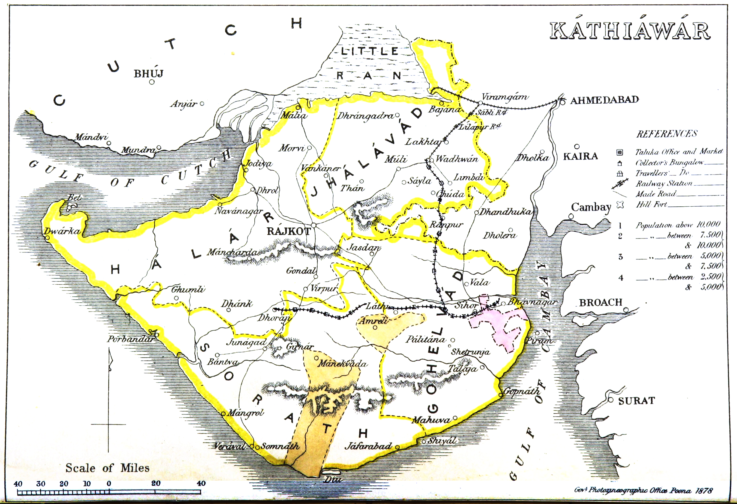
Map
The Kathiawar Map produced by the Government Photographic Department, Poona dated 1878 [7] has been marked up with colour coding to aid identification and provide the time scale of the construction and other proposals of the Railways/Tramways in the Peninsula.
Timeline
The development of the Network followed a chequered history with many false starts.
- 1863-69: Gondal-Ghogha Port Railway Proposals shown in PINK on map.
A railway to connect Gondal to the sea at Ghoga, in the Bay of Cambay was considered important to develop the region.
- There is an unconfirmed record that states ‘During 1863, Maharaja Jaswantsinhji received a proposal to start a Narrow Gauge line like in parts of Gaekwad Railway in Baroda. Maharaja was not inclined, as by that time another company called Ghogha Kathiawad Light Railway Company had been formed... But nothing materialised.’ [8].
- In 1869 another railway from Gogha Port to Gondal was planned by private enterprise, but no surveys were made [9].
It seems probable these two accounts refer to the same proposal, which was not implemented.
- 1872: Bombay, Baroda and Central India Railway (BB&CIR) shown in RED on map.
This 39 mile(63km) broad gauge (BG) branch line from Virangam to Wadhwan opened on 23 May 1872 [5]. This being the first railway in the peninsular.
It was subsequently converted to metre gauge(MG) in 1902[5].
- 1872: Veraval-Junagadh-Dhoraji Railway Proposal Final route shown in GREEN on map - see note.
'Another line was proposed from Veraval to Junagadh and Dhoraji and was surveyed by Mr A W Forde C E, but the cost was beyond the means of Junagadh Durbar. This proposal came to nothing' [9].
Note – it was only in 1888-89 that the Junagadh State Railway(JunSR) opened the line from the docks at Veraval via Junagadh to Jetalsar - see below[10]; where it connected to the Bhavnagar State Railway to Dhoraji
- 1874: Bhavnagar to Wadhwan Railway Proposal Final route shown in GREEN on map - see note.
‘In 1874 a third line was thought of from from Bhavnagar to Wadhwan , but a difference of opinion as to the proper rote and the probable cost prevented action’[9].
Note – this line finally opened in 1880 - see below
References
- ↑ 1.0 1.1 “Imperial Gazette of India” Vol.15. p.164; Retrieved 10 Jun 2017
- ↑ “Imperial Gazette of India” Vol.11. p.362-364; Retrieved 10 Jun 2017
- ↑ Wikipedia “Kathiawar”; Retrieved 10 Jun 2017
- ↑ Wikipedia “Kathiawar Agency”; Retrieved 10 Jun 2017
- ↑ 5.0 5.1 5.2 “Administration Report on Railways 1918” page 22 (pdf30); Retrieved 10 Jun 2017
- ↑ “British Library” IOR R/2/746/306 ‘Document 3 Paragraph 3’ and IOR/1/14784 (1)
- ↑ Wikimedia “Kathiawar Map, 1878”; Retrieved 10 Jun 2017
- ↑ “Bhavnagar, a little Port City of Gujarat – History” Section 4, Para3; Retrieved 10 Jun 2017
- ↑ 9.0 9.1 9.2 “Gazetteer – Bombay Presidency” Vol.8; page 247 of 756; Retrieved 10 Jun 2017
- ↑ “Administration Report on Railways 1918” page 196 (pdf201); Retrieved 10 Jun 2017